
Topografische Karte Herzogenbuchsee
Interaktive Karte
Klicken Sie auf die Karte, um die Höhe anzuzeigen.
Über diese Karte
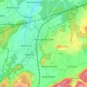
Name: Topografische Karte Herzogenbuchsee, Höhe, Relief.
Durchschnittliche Höhe: 485 m
Minimale Höhe: 438 m
Maximale Höhe: 589 m
Of the built up area, industrial buildings made up 3.1% of the total area while housing and buildings made up 14.2% and transportation infrastructure made up 7.5%. while parks, green belts and sports fields made up 1.5%. 34.0% of the total land area is heavily forested. Of the agricultural land, 30.9% is used for growing crops and 6.1% is pastures. All the water in the municipality is in rivers and streams. The elevation of the train station is 465 m (1,526 ft).
Andere topografische Karten
Klicken Sie auf eine Karte, um ihre Topografie, ihre Höhe und ihr Relief anzuzeigen.
Rohrbach
Switzerland > Bern > Oberaargau administrative district
Rohrbach, Oberaargau administrative district, Emmental-Oberaargau administrative region, Bern, 4938, Switzerland
Durchschnittliche Höhe: 637 m