
Topografische Karte Tynda
Interaktive Karte
Klicken Sie auf die Karte, um die Höhe anzuzeigen.
Über diese Karte
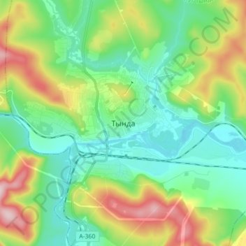
Name: Topografische Karte Tynda, Höhe, Relief.
Durchschnittliche Höhe: 566 m
Minimale Höhe: 477 m
Maximale Höhe: 766 m
The town is located at an elevation of 500 meters (1,600 ft) above sea level, near where the Getkan joins the Tynda River, after which the town was named. The Tynda then flows into the Gilyuy, a tributary of the Zeya, a few kilometers east of the town.