
Topografische Karte Creve Coeur
Interaktive Karte
Klicken Sie auf die Karte, um die Höhe anzuzeigen.
Über diese Karte
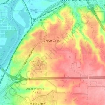
Name: Topografische Karte Creve Coeur, Höhe, Relief.
Ort: Creve Coeur, Tazewell County, Illinois, 61610, United States (40.62213 -89.63710 40.66144 -89.57393)
Durchschnittliche Höhe: 185 m
Minimale Höhe: 132 m
Maximale Höhe: 234 m
Andere topografische Karten
Klicken Sie auf eine Karte, um ihre Topografie, ihre Höhe und ihr Relief anzuzeigen.
North Pekin
United States > Illinois > Tazewell County
North Pekin, Tazewell County, Illinois, United States
Durchschnittliche Höhe: 152 m
Washington
United States > Illinois > Tazewell County
Washington, Tazewell County, Illinois, 61571, United States
Durchschnittliche Höhe: 236 m
Morton
United States > Illinois > Tazewell County
Morton, Tazewell County, Illinois, 61550, United States
Durchschnittliche Höhe: 219 m
East Peoria
United States > Illinois > Tazewell County
East Peoria, Tazewell County, Illinois, 61611, United States
Durchschnittliche Höhe: 176 m
Pekin
United States > Illinois > Tazewell County
Pekin, Tazewell County, Illinois, 61554, United States
Durchschnittliche Höhe: 157 m
Minier
United States > Illinois > Tazewell County
Minier, Tazewell County, Illinois, United States
Durchschnittliche Höhe: 195 m
Hopedale
United States > Illinois > Tazewell County
Hopedale, Tazewell County, Illinois, United States
Durchschnittliche Höhe: 195 m
Green Valley
United States > Illinois > Tazewell County
Green Valley, Tazewell County, Illinois, United States
Durchschnittliche Höhe: 164 m
Mackinaw
United States > Illinois > Tazewell County
Mackinaw, Tazewell County, Illinois, United States
Durchschnittliche Höhe: 198 m