
Topografische Karte Chiusa di Pesio
Interaktive Karte
Klicken Sie auf die Karte, um die Höhe anzuzeigen.
Über diese Karte
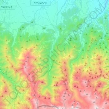
Name: Topografische Karte Chiusa di Pesio, Höhe, Relief.
Ort: Chiusa di Pesio, Cuneo, Piedmont, 12013, Italy (44.17360 7.60340 44.37582 7.71687)
Durchschnittliche Höhe: 1.143 m
Minimale Höhe: 429 m
Maximale Höhe: 2.635 m
Chiusa di Pesio is located at the beginning of the Pesio Valley (its altitude ranges from 575 metres of the main town up to over 2,600 metres of the highest peaks). The main hamlets are San Bartolomeo and Vigna, located in the highest part of the valley, and Combe, Santa Maria Rocca and Abrau which are located more in the plain. Pesio River crosses the whole valley and its spring is called "Pis" (at 1,500 meters above sea level). The town is located between two hills, Mount Cavanero and Mombrisone. On the first one there are the ruins of the Mirabello Castle that dominates the town, and on the second one there is a nineteenth century hunting building. Chiusa di Pesio is 15 km from Cuneo and the nearest motorway is in Mondovì (called A6 Torino-Savona), located about 20 km south of Chiusa di Pesio.
Andere topografische Karten
Klicken Sie auf eine Karte, um ihre Topografie, ihre Höhe und ihr Relief anzuzeigen.
Madonna della Neve
Italy > Piedmont > Cuneo > Clavesana
Madonna della Neve, Clavesana, Cuneo, Piedmont, 12061, Italy
Durchschnittliche Höhe: 329 m
Monte Pennino
Italy > Piedmont > Cuneo > Garessio
Monte Pennino, Garessio, Cuneo, Piedmont, 12075, Italy
Durchschnittliche Höhe: 1.068 m
Costigliole Saluzzo
Costigliole Saluzzo, Cuneo, Piedmont, Italy
Durchschnittliche Höhe: 501 m
Pellerina
Italy > Piedmont > Cuneo > Chiusa di Pesio
Pellerina, Chiusa di Pesio, Cuneo, Piedmont, Italy
Durchschnittliche Höhe: 1.693 m
Colle Fauniera
Italy > Piedmont > Cuneo > Demonte
Colle Fauniera, Demonte, Cuneo, Piedmont, Italy
Durchschnittliche Höhe: 2.315 m
Col Agnel / Colle dell'Agnello
Italy > Piedmont > Cuneo > Pontechianale
Col Agnel / Colle dell'Agnello, Pontechianale, Cuneo, Piedmont, Italy
Durchschnittliche Höhe: 2.700 m
Prato Nevoso
Prato Nevoso, Frabosa Sottana, Cuneo, Piedmont, 12083, Italy
Durchschnittliche Höhe: 1.436 m
Monte Brancetta
Italy > Piedmont > Cuneo > Argentera
Monte Brancetta, Argentera, Cuneo, Piedmont, Italy
Durchschnittliche Höhe: 2.467 m
Bric del Solio
Italy > Piedmont > Cuneo > San Michele Mondovì
Bric del Solio, San Michele Mondovì, Cuneo, Piedmont, Italy
Durchschnittliche Höhe: 646 m
Monviso
Italy > Piedmont > Cuneo > Pontechianale
Monviso, Pontechianale, Cuneo, Piedmont, Italy
Durchschnittliche Höhe: 2.985 m
Monteu Roero
Monteu Roero, Cuneo, Piedmont, Italy
Durchschnittliche Höhe: 307 m
Pratolungo
Italy > Piedmont > Cuneo > Pratolungo
Pratolungo, Vinadio, Cuneo, Piedmont, Italy
Durchschnittliche Höhe: 1.303 m
F.ne Scaglione
Italy > Piedmont > Cuneo > Santo Stefano Belbo > F.ne Scaglione
F.ne Scaglione, Santo Stefano Belbo, Cuneo, Piedmont, 12053, Italy
Durchschnittliche Höhe: 330 m
Santo Stefano Belbo
Italy > Piedmont > Cuneo > Santo Stefano Belbo
Santo Stefano Belbo, Cuneo, Piedmont, 12058, Italy
Durchschnittliche Höhe: 323 m
Monforte d'Alba
Monforte d'Alba, Cuneo, Piedmont, Italy
Durchschnittliche Höhe: 373 m
Castelletto
Castelletto, Roccasparvera, Cuneo, Piedmont, Italy
Durchschnittliche Höhe: 819 m
Sorgente del Po
Italy > Piedmont > Cuneo > Crissolo > Pian del Re
Sorgente del Po, Via Pian del Re, Pian del Re, Crissolo, Cuneo, Piedmont, Italy
Durchschnittliche Höhe: 2.314 m
Limone Piemonte
Limone Piemonte, Cuneo, Piedmont, 12015, Italy
Durchschnittliche Höhe: 1.619 m