
Topografische Karte Land Between the Lakes National Recreation Area
Interaktive Karte
Klicken Sie auf die Karte, um die Höhe anzuzeigen.
Über diese Karte
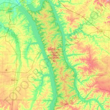
Name: Topografische Karte Land Between the Lakes National Recreation Area, Höhe, Relief.
Durchschnittliche Höhe: 146 m
Minimale Höhe: 92 m
Maximale Höhe: 246 m
The United States Army Corps of Engineers constructed a dam on the Cumberland, producing another lake. It was planned to be at the same elevation as Kentucky Lake, and the two rivers were to be connected by a canal that did not require locks. This project was intended to lessen the shipping distances for goods going from the Cumberland Valley to ports on the Gulf of Mexico, thus increasing their profitability.
Andere topografische Karten
Klicken Sie auf eine Karte, um ihre Topografie, ihre Höhe und ihr Relief anzuzeigen.
Cadiz
United States > Kentucky > Trigg County
Cadiz, Trigg County, Kentucky, United States
Durchschnittliche Höhe: 141 m
Canton
United States > Kentucky > Trigg County
Canton, Trigg County, Kentucky, United States
Durchschnittliche Höhe: 122 m
Rockcastle
United States > Kentucky > Trigg County > Rockcastle
Rockcastle, Trigg County, Kentucky, United States
Durchschnittliche Höhe: 117 m