
Topografische Karte Arciprestazgo de Alcalá Sur
Interaktive Karte
Klicken Sie auf die Karte, um die Höhe anzuzeigen.
Über diese Karte
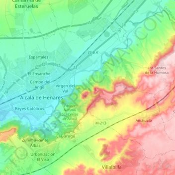
Name: Topografische Karte Arciprestazgo de Alcalá Sur, Höhe, Relief.
Durchschnittliche Höhe: 685 m
Minimale Höhe: 576 m
Maximale Höhe: 899 m
Standing at an average altitude of 654 m, and occupying some 88 km2; the city was for a long time contained in between the Henares to the South and the Madrid-Barcelona railway to the North. However, the increasing population brought on the sprawl of the urbanised area to the area located in between the railway and the A-2 motorway and beyond.