
Topografische Karte Vergne
Interaktive Karte
Klicken Sie auf die Karte, um die Höhe anzuzeigen.
Über diese Karte
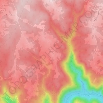
Name: Topografische Karte Vergne, Höhe, Relief.
Durchschnittliche Höhe: 522 m
Minimale Höhe: 255 m
Maximale Höhe: 605 m
Andere topografische Karten
Klicken Sie auf eine Karte, um ihre Topografie, ihre Höhe und ihr Relief anzuzeigen.
Le Mas
France > Nouvelle-Aquitaine > Corrèze > Marcillac-la-Croisille
Le Mas, Marcillac-la-Croisille, Ussel, Corrèze, Nouvelle-Aquitaine, France métropolitaine, 19320, France
Durchschnittliche Höhe: 482 m
Nougein
France > Nouvelle-Aquitaine > Corrèze > Marcillac-la-Croisille
Nougein, Marcillac-la-Croisille, Ussel, Corrèze, Nouvelle-Aquitaine, France métropolitaine, 19320, France
Durchschnittliche Höhe: 474 m
Cireygeol
France > Nouvelle-Aquitaine > Corrèze > Marcillac-la-Croisille
Cireygeol, Marcillac-la-Croisille, Ussel, Corrèze, Nouvelle-Aquitaine, France métropolitaine, 19320, France
Durchschnittliche Höhe: 535 m