
Topografische Karte Larne
Interaktive Karte
Klicken Sie auf die Karte, um die Höhe anzuzeigen.
Über diese Karte
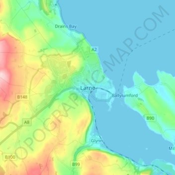
Name: Topografische Karte Larne, Höhe, Relief.
Durchschnittliche Höhe: 54 m
Minimale Höhe: -2 m
Maximale Höhe: 229 m
Andere topografische Karten
Klicken Sie auf eine Karte, um ihre Topografie, ihre Höhe und ihr Relief anzuzeigen.
Randalstown
United Kingdom > Northern Ireland > County Antrim
Randalstown, County Antrim, Northern Ireland, BT41 3AD, United Kingdom
Durchschnittliche Höhe: 57 m
Belfast
United Kingdom > Northern Ireland > County Antrim
Belfast, County Antrim, Northern Ireland, United Kingdom
Durchschnittliche Höhe: 92 m
Carrickfergus
United Kingdom > Northern Ireland > County Antrim
Carrickfergus, County Antrim, Ulster, Northern Ireland, BT38 7AF, United Kingdom
Durchschnittliche Höhe: 49 m
Antrim
United Kingdom > Northern Ireland > County Antrim > Antrim
Antrim, County Antrim, Northern Ireland, BT41 4AR, United Kingdom
Durchschnittliche Höhe: 50 m
Ballymena
United Kingdom > Northern Ireland > County Antrim > Ballymena
Ballymena, County Antrim, Northern Ireland, BT43 6AH, United Kingdom
Durchschnittliche Höhe: 74 m
Old Mill
United Kingdom > Northern Ireland > County Antrim > Ballygally > Old Mill
Old Mill, Ballygally, County Antrim, Northern Ireland, BT40 2RX, United Kingdom
Durchschnittliche Höhe: 47 m
Bushmills
United Kingdom > Northern Ireland > County Antrim
Bushmills, County Antrim, Ulster, Northern Ireland, BT57 8QB, United Kingdom
Durchschnittliche Höhe: 42 m
Lisburn
United Kingdom > Northern Ireland > County Antrim
Lisburn, County Antrim, Northern Ireland, BT28 1BJ, United Kingdom
Durchschnittliche Höhe: 92 m