
Topografische Karte Conklin
Interaktive Karte
Klicken Sie auf die Karte, um die Höhe anzuzeigen.
Über diese Karte
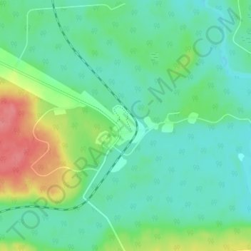
Name: Topografische Karte Conklin, Höhe, Relief.
Ort: Conklin, Wood Buffalo, Alberta, T0P 1H0, Canada (55.61250 -111.10278 55.65250 -111.06278)
Durchschnittliche Höhe: 571 m
Minimale Höhe: 550 m
Maximale Höhe: 623 m
Conklin is a hamlet in northern Alberta, Canada within the Regional Municipality (RM) of Wood Buffalo. It is located on Highway 881 between Fort McMurray and Lac La Biche. It lies near the west end of Christina Lake at an elevation of 575 metres (1,886 ft), and was named for John Conklin, a railroad employee.
Andere topografische Karten
Klicken Sie auf eine Karte, um ihre Topografie, ihre Höhe und ihr Relief anzuzeigen.
Christina Lake
Canada > Alberta > Wood Buffalo > Conklin
Christina Lake, Conklin, Wood Buffalo, Alberta, Canada
Durchschnittliche Höhe: 573 m