
Topografische Karte Chazey-Bons
Interaktive Karte
Klicken Sie auf die Karte, um die Höhe anzuzeigen.
Über diese Karte
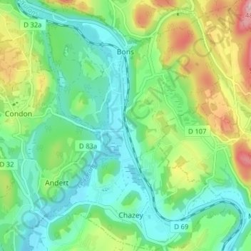
Name: Topografische Karte Chazey-Bons, Höhe, Relief.
Durchschnittliche Höhe: 297 m
Minimale Höhe: 224 m
Maximale Höhe: 461 m
Andere topografische Karten
Klicken Sie auf eine Karte, um ihre Topografie, ihre Höhe und ihr Relief anzuzeigen.
Pugieu
France > Auvergne-Rhône-Alpes > Ain > Chazey-Bons
Pugieu, Chazey-Bons, Belley, Ain, Auvergne-Rhône-Alpes, France métropolitaine, 01510, France
Durchschnittliche Höhe: 361 m
Rothonod
France > Auvergne-Rhône-Alpes > Ain > Chazey-Bons
Rothonod, Chazey-Bons, Belley, Ain, Auvergne-Rhône-Alpes, France métropolitaine, 01300, France
Durchschnittliche Höhe: 282 m