
Topografische Karte Bernalillo County
Interaktive Karte
Klicken Sie auf die Karte, um die Höhe anzuzeigen.
Über diese Karte
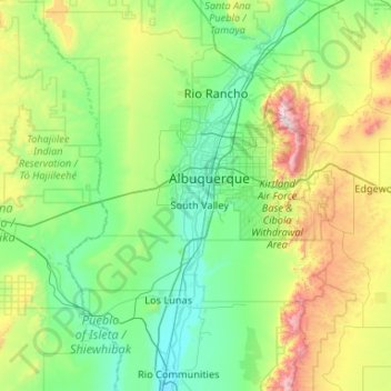
Name: Topografische Karte Bernalillo County, Höhe, Relief.
Ort: Bernalillo County, New Mexico, USA (34.86967 -107.19719 35.21942 -106.14457)
Durchschnittliche Höhe: 1.808 m
Minimale Höhe: 1.459 m
Maximale Höhe: 3.236 m
Andere topografische Karten
Klicken Sie auf eine Karte, um ihre Topografie, ihre Höhe und ihr Relief anzuzeigen.
Truchas Peak
Truchas Peak, Rio Arriba County, New Mexico, USA
Durchschnittliche Höhe: 3.639 m
Manzano Mountains
USA > New Mexico > D Candelaria Place
Manzano Mountains, D Candelaria Place, Torrance County, New Mexico, USA
Durchschnittliche Höhe: 2.211 m
Sandia Mountains Historical Marker
USA > New Mexico > Tierra Monte Subdivision
Sandia Mountains Historical Marker, Tierra Monte Subdivision, Bernalillo County, New Mexico, USA
Durchschnittliche Höhe: 2.938 m
Plate Mesa
Plate Mesa, Bernalillo County, New Mexico, USA
Durchschnittliche Höhe: 1.845 m
Sacramento
USA > New Mexico > Sacramento
Sacramento, Otero County, New Mexico, 88354, USA
Durchschnittliche Höhe: 2.320 m
El Rancho
USA > New Mexico > El Rancho
El Rancho, Santa Fe County, New Mexico, USA
Durchschnittliche Höhe: 1.743 m