
Topografische Karte Sincelejo
Interaktive Karte
Klicken Sie auf die Karte, um die Höhe anzuzeigen.
Sincelejo
The geography of Sincelejo is characterized by a hilly landscape which extends from the mountains to the borders of the plateau in the north and south. The small mountain foothills in the municipality span from the marine fluvial plain in the west to the border shared with the town of Palmito. Erosion is common in the rugged topography of the rolling hills, which are moderately to strongly broken, with slopes between 7 and 50% and altitudes ranging from 50 to 260 meters.
Über diese Karte
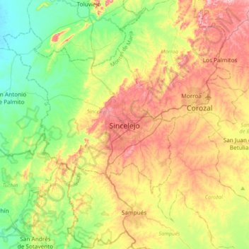
Name: Topografische Karte Sincelejo, Höhe, Relief.
Durchschnittliche Höhe: 121 m
Minimale Höhe: 15 m
Maximale Höhe: 274 m