
Topografische Karte Ashbourne CP
Interaktive Karte
Klicken Sie auf die Karte, um die Höhe anzuzeigen.
Ashbourne CP
Ashbourne lies at 53°01′N 01°44′W / 53.017°N 1.733°W / 53.017; -1.733. Ashbourne Green and Sturston are hamlets close by. Henmore Brook, a tributary of the River Dove, flows through the middle of the town. It has an elevation of 400 feet (122 m).
Über diese Karte
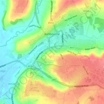
Name: Topografische Karte Ashbourne CP, Höhe, Relief.
Durchschnittliche Höhe: 147 m
Minimale Höhe: 112 m
Maximale Höhe: 187 m
Andere topografische Karten
Klicken Sie auf eine Karte, um ihre Topografie, ihre Höhe und ihr Relief anzuzeigen.