
Topografische Karte Jackson
Interaktive Karte
Klicken Sie auf die Karte, um die Höhe anzuzeigen.
Über diese Karte
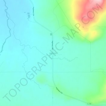
Name: Topografische Karte Jackson, Höhe, Relief.
Ort: Jackson, Beaverhead County, Montana, 59736, United States (45.34813 -113.42908 45.38813 -113.38908)
Durchschnittliche Höhe: 1.995 m
Minimale Höhe: 1.952 m
Maximale Höhe: 2.159 m
Andere topografische Karten
Klicken Sie auf eine Karte, um ihre Topografie, ihre Höhe und ihr Relief anzuzeigen.
Red Rock River
United States > Montana > Beaverhead County > Dell
Red Rock River, Dell, Beaverhead County, Montana, United States
Durchschnittliche Höhe: 1.834 m
Wisdom
United States > Montana > Beaverhead County > Wisdom
Wisdom, Beaverhead County, Montana, 59761, United States
Durchschnittliche Höhe: 1.848 m
Ski Hill
United States > Montana > Beaverhead County
Ski Hill, Beaverhead County, Montana, United States
Durchschnittliche Höhe: 2.215 m
Dillon
United States > Montana > Beaverhead County
Dillon, Beaverhead County, Montana, United States
Durchschnittliche Höhe: 1.562 m
Bannack
United States > Montana > Beaverhead County
Bannack, Beaverhead County, Montana, United States
Durchschnittliche Höhe: 1.877 m