
Spenden
Rüsten Sie sich für Ihr nächstes Abenteuer:
Als Amazon-Partner erhält diese Website eine Provision für qualifizierte Käufe, ohne zusätzliche Kosten für Sie.
Topografische Karte Weber County
Klicken Sie auf die Karte, um die Höhe anzuzeigen.
Spenden
Rüsten Sie sich für Ihr nächstes Abenteuer:
Als Amazon-Partner erhält diese Website eine Provision für qualifizierte Käufe, ohne zusätzliche Kosten für Sie.
Weber County
The county extends from high in the Wasatch Range in the east into a portion of the Great Salt Lake to the west, where the county's elongated point exists. The Weber and Ogden rivers and their tributaries run through its valleys. The Weber County Surveyor's office divides the county into two regions, the "Lower Valley" and the "Upper Valley", divided by the ridge of the Wasatch front range south through the county. Lower Valley, adjacent to the Lake, is the county's more populous part. The Upper Valley consists mostly of the Ogden Valley, the watershed of the Ogden River. The county's highest elevation is Willard Peak in the Wasatch Mountains, at 9,763' (2976m) ASL. The county has an area of 659 square miles (1,710 km2), of which 576 square miles (1,490 km2) is land and 83 square miles (210 km2) (13%) is water. It is the second-smallest county in Utah by land area and third-smallest by total area.
Spenden
Rüsten Sie sich für Ihr nächstes Abenteuer:
Als Amazon-Partner erhält diese Website eine Provision für qualifizierte Käufe, ohne zusätzliche Kosten für Sie.
Über diese Karte
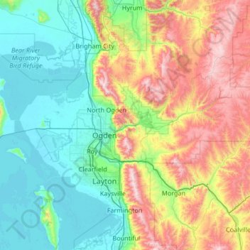
Name: Topografische Karte Weber County, Höhe, Relief.
Ort: Weber County, Utah, United States (41.07684 -112.49348 41.43393 -111.42038)
Durchschnittliche Höhe: 1.722 m
Minimale Höhe: 1.278 m
Maximale Höhe: 2.919 m
Spenden
Rüsten Sie sich für Ihr nächstes Abenteuer:
Als Amazon-Partner erhält diese Website eine Provision für qualifizierte Käufe, ohne zusätzliche Kosten für Sie.
Andere topografische Karten
Klicken Sie auf eine Karte, um ihre Topografie, ihre Höhe und ihr Relief anzuzeigen.
Uinta Mountains
The high Uintas were extensively glaciated during the last ice age, and most of the large stream valleys on both the north and south sides of the range held long valley glaciers. However, despite reaching to over 13,500 feet (4,110 m) in elevation, the climate today is sufficiently dry that no glaciers…
Durchschnittliche Höhe: 2.363 m
Spenden
Rüsten Sie sich für Ihr nächstes Abenteuer:
Als Amazon-Partner erhält diese Website eine Provision für qualifizierte Käufe, ohne zusätzliche Kosten für Sie.
Antelope Island
United States > Utah > Davis County
The island is accessible via a 7-mile causeway from Syracuse in Davis County. Access from Interstate 15 is via exit 332, then west along Antelope Drive (SR-108). The island's shore (all but west side of the island) is mostly flat with beaches and plains to the base of the mountains on the island. These steep…
Durchschnittliche Höhe: 1.306 m
Spenden
Rüsten Sie sich für Ihr nächstes Abenteuer:
Als Amazon-Partner erhält diese Website eine Provision für qualifizierte Käufe, ohne zusätzliche Kosten für Sie.
Spenden
Rüsten Sie sich für Ihr nächstes Abenteuer:
Als Amazon-Partner erhält diese Website eine Provision für qualifizierte Käufe, ohne zusätzliche Kosten für Sie.
Spenden
Rüsten Sie sich für Ihr nächstes Abenteuer:
Als Amazon-Partner erhält diese Website eine Provision für qualifizierte Käufe, ohne zusätzliche Kosten für Sie.
Century Communities
United States > Utah > Salt Lake County > Herriman
Durchschnittliche Höhe: 1.468 m
Spenden
Rüsten Sie sich für Ihr nächstes Abenteuer:
Als Amazon-Partner erhält diese Website eine Provision für qualifizierte Käufe, ohne zusätzliche Kosten für Sie.
Spenden
Rüsten Sie sich für Ihr nächstes Abenteuer:
Als Amazon-Partner erhält diese Website eine Provision für qualifizierte Käufe, ohne zusätzliche Kosten für Sie.
Draper Commercial Parkway
United States > Utah > Salt Lake County > Draper
Durchschnittliche Höhe: 1.355 m
Spenden
Rüsten Sie sich für Ihr nächstes Abenteuer:
Als Amazon-Partner erhält diese Website eine Provision für qualifizierte Käufe, ohne zusätzliche Kosten für Sie.
Mountains Meadows
United States > Utah > Davis County > North Salt Lake
Durchschnittliche Höhe: 1.411 m
Spenden
Rüsten Sie sich für Ihr nächstes Abenteuer:
Als Amazon-Partner erhält diese Website eine Provision für qualifizierte Käufe, ohne zusätzliche Kosten für Sie.
Federal Heights
United States > Utah > Salt Lake County > Salt Lake City
Durchschnittliche Höhe: 1.537 m
Spenden
Rüsten Sie sich für Ihr nächstes Abenteuer:
Als Amazon-Partner erhält diese Website eine Provision für qualifizierte Käufe, ohne zusätzliche Kosten für Sie.
Spenden
Rüsten Sie sich für Ihr nächstes Abenteuer:
Als Amazon-Partner erhält diese Website eine Provision für qualifizierte Käufe, ohne zusätzliche Kosten für Sie.
Spenden
Rüsten Sie sich für Ihr nächstes Abenteuer:
Als Amazon-Partner erhält diese Website eine Provision für qualifizierte Käufe, ohne zusätzliche Kosten für Sie.
Jordan River OHV/ Modelport State Park
United States > Utah > Salt Lake County > Salt Lake City
Durchschnittliche Höhe: 1.286 m
Spenden
Rüsten Sie sich für Ihr nächstes Abenteuer:
Als Amazon-Partner erhält diese Website eine Provision für qualifizierte Käufe, ohne zusätzliche Kosten für Sie.
Spenden
Rüsten Sie sich für Ihr nächstes Abenteuer:
Als Amazon-Partner erhält diese Website eine Provision für qualifizierte Käufe, ohne zusätzliche Kosten für Sie.
Spenden
Rüsten Sie sich für Ihr nächstes Abenteuer:
Als Amazon-Partner erhält diese Website eine Provision für qualifizierte Käufe, ohne zusätzliche Kosten für Sie.
Spenden
Rüsten Sie sich für Ihr nächstes Abenteuer:
Als Amazon-Partner erhält diese Website eine Provision für qualifizierte Käufe, ohne zusätzliche Kosten für Sie.
Zion Canyon
United States > Utah > Washington County
Geologically Zion Canyon is part of the Navajo sandstone Colorado Plateau, which contained many joints and cracks when first uplifted, one of which was cut by the North Fork of the Virgin River to become Zion Canyon. The river was the largest force in cutting the canyon, mostly by flash floods, as the average…
Durchschnittliche Höhe: 1.821 m
Mount Ellen
United States > Utah > Garfield County
Mount Ellen is an ultra prominent peak, meaning that it has more than 1,500 metres (4,921 ft) of topographic prominence, standing out considerably from nearby mountains. It stands in the watershed of the Fremont River, which together with Muddy Creek forms the Dirty Devil River, which drains into the Colorado…
Durchschnittliche Höhe: 3.149 m
Spenden
Rüsten Sie sich für Ihr nächstes Abenteuer:
Als Amazon-Partner erhält diese Website eine Provision für qualifizierte Käufe, ohne zusätzliche Kosten für Sie.
Midway City Hamlet Park
United States > Utah > Wasatch County > Midway
Durchschnittliche Höhe: 1.690 m
Spenden
Rüsten Sie sich für Ihr nächstes Abenteuer:
Als Amazon-Partner erhält diese Website eine Provision für qualifizierte Käufe, ohne zusätzliche Kosten für Sie.
Riverton Majestic Village
United States > Utah > Salt Lake County > Riverton
Durchschnittliche Höhe: 1.369 m
Spenden
Rüsten Sie sich für Ihr nächstes Abenteuer:
Als Amazon-Partner erhält diese Website eine Provision für qualifizierte Käufe, ohne zusätzliche Kosten für Sie.
Spenden
Rüsten Sie sich für Ihr nächstes Abenteuer:
Als Amazon-Partner erhält diese Website eine Provision für qualifizierte Käufe, ohne zusätzliche Kosten für Sie.
Spenden
Rüsten Sie sich für Ihr nächstes Abenteuer:
Als Amazon-Partner erhält diese Website eine Provision für qualifizierte Käufe, ohne zusätzliche Kosten für Sie.
Bear Lake
United States > Utah > Rich County > Garden City
Formed in a half graben valley straddling the Idaho-Utah border, the lake has an approximate area of 109 square miles (280 km2) and sits at an elevation of 5,924 feet (1,806 m) along the northeast side of the Wasatch Range and the east side of the Bear River Mountains.
Durchschnittliche Höhe: 2.038 m
Spenden
Rüsten Sie sich für Ihr nächstes Abenteuer:
Als Amazon-Partner erhält diese Website eine Provision für qualifizierte Käufe, ohne zusätzliche Kosten für Sie.
Spenden
Rüsten Sie sich für Ihr nächstes Abenteuer:
Als Amazon-Partner erhält diese Website eine Provision für qualifizierte Käufe, ohne zusätzliche Kosten für Sie.
Anderson Junction
United States > Utah > Washington County > Toquerville
Durchschnittliche Höhe: 1.189 m
Colorado Plateau
United States > Utah > San Juan County
Younger igneous rocks form spectacular topographic features. The Henry Mountains, La Sal Range, and Abajo Mountains, ranges that dominate many views in southeastern Utah, are formed about igneous rocks that were intruded in the interval from 20 to 31 million years: some igneous intrusions in these mountains…
Durchschnittliche Höhe: 1.512 m
Spenden
Rüsten Sie sich für Ihr nächstes Abenteuer:
Als Amazon-Partner erhält diese Website eine Provision für qualifizierte Käufe, ohne zusätzliche Kosten für Sie.
Kings Peak
United States > Utah > Duchesne County
Kings Peak is the highest peak in the U.S. state of Utah, with an elevation of 13,528 feet (4,123 m) NAVD 88.
Durchschnittliche Höhe: 3.743 m
Spenden
Rüsten Sie sich für Ihr nächstes Abenteuer:
Als Amazon-Partner erhält diese Website eine Provision für qualifizierte Käufe, ohne zusätzliche Kosten für Sie.
Angels Landing
United States > Utah > Washington County
The trail to Angels Landing is 2.5 miles (4.0 km) long with an approximate 1,500 feet (460 m) elevation gain. The hike is rated as a class 3 difficulty based on the Yosemite Decimal System. It begins at the Grotto drop-off point on the park's shuttle system, which operates from early spring through late fall.…
Durchschnittliche Höhe: 1.695 m
Spenden
Rüsten Sie sich für Ihr nächstes Abenteuer:
Als Amazon-Partner erhält diese Website eine Provision für qualifizierte Käufe, ohne zusätzliche Kosten für Sie.