Geolokalisieren

Topografische Karte Rio Almansor

Klicken Sie auf die Karte, um die Höhe anzuzeigen.

Über diese Karte
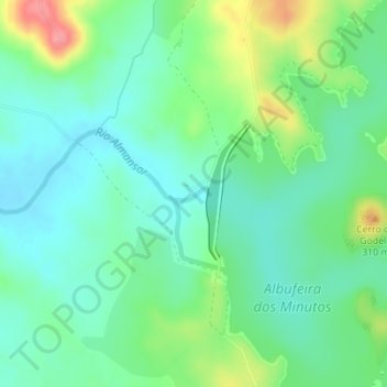
Name: Topografische Karte Rio Almansor, Höhe, Relief.

Ort: Rio Almansor, Nossa Senhora da Vila, Nossa Senhora do Bispo e Silveiras, Montemor-o-Novo, Évora, 7050-349, Portugal (38.65900 -8.10187 38.65991 -8.09883)

Durchschnittliche Höhe: 257 m

Minimale Höhe: 230 m

Maximale Höhe: 321 m

Andere topografische Karten

Klicken Sie auf eine Karte, um ihre Topografie, ihre Höhe und ihr Relief anzuzeigen.

Cabrela

Portugal > Évora > Montemor-o-Novo

Durchschnittliche Höhe: 110 m

São Cristóvão

Portugal > Évora > Montemor-o-Novo

Durchschnittliche Höhe: 180 m

Foros de Vale de Figueira

Portugal > Évora > Montemor-o-Novo

Durchschnittliche Höhe: 150 m

Escoural

Portugal > Évora > Montemor-o-Novo

Durchschnittliche Höhe: 269 m

Santa Sofia

Portugal > Évora > Montemor-o-Novo

Durchschnittliche Höhe: 299 m

Albufeira dos Minutos

Portugal > Évora > Montemor-o-Novo

Durchschnittliche Höhe: 268 m

Barragem dos Minutos

Portugal > Évora > Montemor-o-Novo

Durchschnittliche Höhe: 257 m

Montemor

Portugal > Évora > Montemor-o-Novo

Durchschnittliche Höhe: 222 m

Foros de Vale de Figueira

Portugal > Évora > Montemor-o-Novo

Durchschnittliche Höhe: 150 m

Rüsten Sie sich für Ihr nächstes Abenteuer:

👕Merino-Funktionswäsche - Natürliche Thermoregulation für jede Jahreszeit
🧳Reisetasche mit Rollen - Große Reisetasche ideal für Outdoor‑Trips
🧥Softshell Jacke Outdoor - Flexibel und winddicht für wechselhaftes Wetter
🧯Feuerstarter Set - Zuverlässiger Feuerstarter für Camping
🗺️Topografische Wanderkarten - Gedruckte Regionalkarten für Deutschland im Maßstab 1:25.000

Als Amazon-Partner erhält diese Website eine Provision für qualifizierte Käufe, ohne zusätzliche Kosten für Sie.