
Spenden
Rüsten Sie sich für Ihr nächstes Abenteuer:
Als Amazon-Partner erhält diese Website eine Provision für qualifizierte Käufe, ohne zusätzliche Kosten für Sie.
Topografische Karte Suches
Klicken Sie auf die Karte, um die Höhe anzuzeigen.
Spenden
Rüsten Sie sich für Ihr nächstes Abenteuer:
Als Amazon-Partner erhält diese Website eine Provision für qualifizierte Käufe, ohne zusätzliche Kosten für Sie.
Über diese Karte
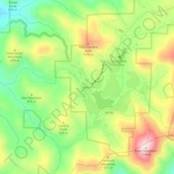
Name: Topografische Karte Suches, Höhe, Relief.
Ort: Suches, Union County, Georgia, United States (34.66898 -84.04214 34.70898 -84.00214)
Durchschnittliche Höhe: 871 m
Minimale Höhe: 670 m
Maximale Höhe: 1.125 m
Spenden
Rüsten Sie sich für Ihr nächstes Abenteuer:
Als Amazon-Partner erhält diese Website eine Provision für qualifizierte Käufe, ohne zusätzliche Kosten für Sie.
Andere topografische Karten
Klicken Sie auf eine Karte, um ihre Topografie, ihre Höhe und ihr Relief anzuzeigen.
Blairsville
United States > Georgia > Union County
Blairsville, Georgia, is situated in the picturesque Appalachian Mountains, characterized by a varied topography that includes rolling hills, lush valleys, and prominent mountain ridges. The elevation of the town itself is approximately 1,800 feet, providing breathtaking views of the surrounding landscape. The…
Durchschnittliche Höhe: 587 m
Blairsville
United States > Georgia > Union County
Blairsville has a humid subtropical climate, yet due to its elevation of 1,883 feet (574 m), typically records far lower temperatures at night than what is encountered in much of the Southeastern U.S., and has slightly higher precipitation totals (56 inches or 1,420 millimetres annually) than most locations in…
Durchschnittliche Höhe: 587 m