
Topografische Karte Lorton
Interaktive Karte
Klicken Sie auf die Karte, um die Höhe anzuzeigen.
Lorton
According to the United States Census Bureau, the Lorton CDP has a total area of 5.4 square miles (13.9 km2), of which 5.3 square miles (13.7 km2) is land and 0.1 square miles (0.2 km2), or 1.39%, is water. The elevation ranges from sea level at the Prince William County line (the Occoquan River) to slightly over 200 feet (61 m) along Furnace Road at the CDP's western edge.
Über diese Karte
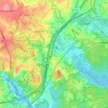
Name: Topografische Karte Lorton, Höhe, Relief.
Ort: Lorton, Fairfax County, Virginia, United States (38.66687 -77.28193 38.73371 -77.19295)
Durchschnittliche Höhe: 41 m
Minimale Höhe: -4 m
Maximale Höhe: 107 m
Andere topografische Karten
Klicken Sie auf eine Karte, um ihre Topografie, ihre Höhe und ihr Relief anzuzeigen.