
Topografische Karte Cloudcroft
Interaktive Karte
Klicken Sie auf die Karte, um die Höhe anzuzeigen.
Über diese Karte
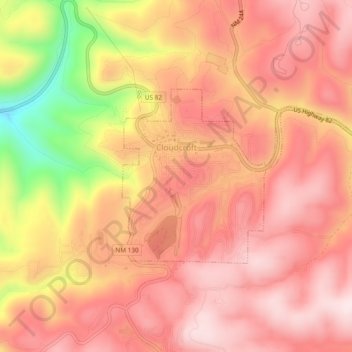
Name: Topografische Karte Cloudcroft, Höhe, Relief.
Ort: Cloudcroft, Otero County, New Mexico, United States (32.94456 -105.75004 32.96421 -105.70277)
Durchschnittliche Höhe: 2.643 m
Minimale Höhe: 2.352 m
Maximale Höhe: 2.776 m
Cloudcroft is a village in Otero County, New Mexico, United States, and is located within the Lincoln National Forest. The population was 674 at the 2010 census. Despite being located in an otherwise arid region, its high elevation (8,676 feet (2,644 m); one of the highest in the U.S.) allows for a mild summer that makes it a popular tourist attraction in west Texas and southern New Mexico. It was named by Fodor's in 2002 as the Number 3 "Most Overlooked and Underrated Destination Spot." Tourism remains the primary economic driver of the village.
Andere topografische Karten
Klicken Sie auf eine Karte, um ihre Topografie, ihre Höhe und ihr Relief anzuzeigen.
Alamorosa
United States > New Mexico > Otero County
Alamorosa, Otero County, New Mexico, 88337, United States
Durchschnittliche Höhe: 1.365 m
La Luz
United States > New Mexico > Otero County
La Luz, Otero County, New Mexico, 88337, United States
Durchschnittliche Höhe: 1.452 m
Orogrande
United States > New Mexico > Otero County
Orogrande, Otero County, New Mexico, 88342, United States
Durchschnittliche Höhe: 1.285 m
Weed
United States > New Mexico > Otero County
Weed, Otero County, New Mexico, 88354, United States
Durchschnittliche Höhe: 2.212 m
Timberon
United States > New Mexico > Otero County
Timberon, Otero County, New Mexico, 88350, United States
Durchschnittliche Höhe: 2.181 m
Apache
United States > New Mexico > Otero County
Apache, Otero County, New Mexico, United States
Durchschnittliche Höhe: 1.957 m
Cloudcroft
United States > New Mexico > Otero County > Cloudcroft
Cloudcroft, Otero County, New Mexico, 88317, United States
Durchschnittliche Höhe: 2.636 m
White Sands National Park
United States > New Mexico > Otero County
White Sands National Park, Otero County, New Mexico, United States
Durchschnittliche Höhe: 1.214 m
Alamogordo
United States > New Mexico > Otero County
Alamogordo, Otero County, New Mexico, 88310, United States
Durchschnittliche Höhe: 1.644 m
Alamogordo
United States > New Mexico > Otero County
Alamogordo, Otero County, New Mexico, United States
Durchschnittliche Höhe: 1.515 m
La Luz
United States > New Mexico > Otero County
La Luz, Otero County, New Mexico, 88337, United States
Durchschnittliche Höhe: 1.493 m
Mayhill
United States > New Mexico > Otero County
Mayhill, Otero County, New Mexico, United States
Durchschnittliche Höhe: 2.104 m
High Rolls
United States > New Mexico > Otero County
High Rolls, Otero County, New Mexico, 88325, United States
Durchschnittliche Höhe: 2.036 m
Sacramento
United States > New Mexico > Otero County
Sacramento, Otero County, New Mexico, 88347, United States
Durchschnittliche Höhe: 2.320 m