
Topografische Karte Grand Cayman
Interaktive Karte
Klicken Sie auf die Karte, um die Höhe anzuzeigen.
Über diese Karte
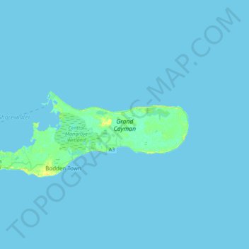
Name: Topografische Karte Grand Cayman, Höhe, Relief.
Ort: Grand Cayman, Cayman Islands (19.26290 -81.42021 19.39685 -81.08468)
Durchschnittliche Höhe: 1 m
Minimale Höhe: 0 m
Maximale Höhe: 16 m
Grand Cayman encompasses 76% of the territory's entire land mass. The island is approximately 22 miles (35 km) long with its widest point being 8 miles (13 km) wide. The elevation ranges from sea level at the beaches to 60 feet (18 m) above sea level on the North Side's Mastic Trail. Unlike many other Caribbean islands, Grand Cayman is for the most part, flat. This allows for more space to build as the island’s population grows.
Andere topografische Karten
Klicken Sie auf eine Karte, um ihre Topografie, ihre Höhe und ihr Relief anzuzeigen.
Beach Bay
Cayman Islands > South Cayman Palms
Beach Bay, South Cayman Palms, KY1-1105, Cayman Islands
Durchschnittliche Höhe: 4 m
Whitehall Estate
Whitehall Estate, West Bay, KY1-1202, Cayman Islands
Durchschnittliche Höhe: 3 m
Little Cayman
Little Cayman, Sister Islands, KY3-2501, Cayman Islands
Durchschnittliche Höhe: 1 m
Northward
Cayman Islands > Bodden Town > Northward
Northward, Bodden Town, KY1-1105, Cayman Islands
Durchschnittliche Höhe: 6 m
Cork Landing
Cork Landing, Sister Islands, Cayman Islands
Durchschnittliche Höhe: 2 m
Old Isaacs
Old Isaacs, KY1-1702, Cayman Islands
Durchschnittliche Höhe: 2 m
North Side
North Side, KY1-1601, Cayman Islands
Durchschnittliche Höhe: 0 m
Drift Wood Village
Cayman Islands > Drift Wood Village
Drift Wood Village, Cayman Islands
Durchschnittliche Höhe: 2 m