Geolokalisieren

Topografische Karte Parque Nacional Tierra del Fuego

Interaktive Karte

Klicken Sie auf die Karte, um die Höhe anzuzeigen.

Über diese Karte

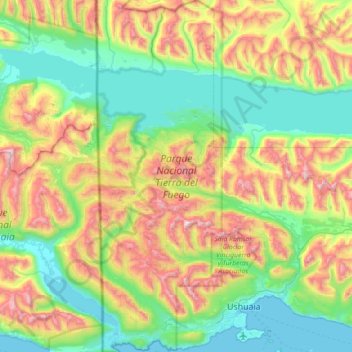
Name: Topografische Karte Parque Nacional Tierra del Fuego, Höhe, Relief.

Ort: Parque Nacional Tierra del Fuego, Departamento Ushuaia, Tierra del Fuego Province, Argentina (-54.86083 -68.60747 -54.44550 -68.35172)

Durchschnittliche Höhe: 460 m

Minimale Höhe: 0 m

Maximale Höhe: 1.470 m

The park has dramatic scenery, with waterfalls, forests, mountains, and glaciers. Its 630 km2 (240 sq mi) include parts of the Fagnano and Roca lakes. The Senda Costera (Coastal Path), connecting Ensenada Bay to Lapataia Bay on Lago Roca, is a popular hiking trail within the park. Forests of Antarctic beech, lenga beech, and coihue in the lower elevations of the park are home to many animal species. There are 20 species of terrestrial mammals, including the guanaco, Andean fox, North American beaver, European rabbit and muskrat. Among the 90 species of birds are the kelp goose, torrent duck, austral parakeet, Andean condor, blackish oystercatcher, and Magellanic oystercatcher.

Wikipedia (CC-BY-SA 3.0)

Andere topografische Karten

Klicken Sie auf eine Karte, um ihre Topografie, ihre Höhe und ihr Relief anzuzeigen.

Tolhuin

Argentina > Tierra del Fuego Province

Tolhuin, Municipio de Tolhuin, Departamento Tolhuin, Tierra del Fuego Province, Argentina

Durchschnittliche Höhe: 97 m

Rio Grande

Argentina > Tierra del Fuego Province

Rio Grande, Departamento Río Grande, Tierra del Fuego Province, 9420, Argentina

Durchschnittliche Höhe: 23 m

Ushuaia

Argentina > Tierra del Fuego Province > Ushuaia

Ushuaia, Departamento Ushuaia, Tierra del Fuego Province, Argentina

Durchschnittliche Höhe: 232 m

Departamento Ushuaia

Argentina > Tierra del Fuego Province

Departamento Ushuaia, Tierra del Fuego Province, Argentina, Laguna del Caminante

Durchschnittliche Höhe: 671 m

Rio Grande

Argentina > Tierra del Fuego Province

Rio Grande, Departamento Río Grande, Tierra del Fuego Province, 9420, Argentina

Durchschnittliche Höhe: 6 m