
Spenden
Rüsten Sie sich für Ihr nächstes Abenteuer:
Als Amazon-Partner erhält diese Website eine Provision für qualifizierte Käufe, ohne zusätzliche Kosten für Sie.
Topografische Karte Angwin
Klicken Sie auf die Karte, um die Höhe anzuzeigen.
Spenden
Rüsten Sie sich für Ihr nächstes Abenteuer:
Als Amazon-Partner erhält diese Website eine Provision für qualifizierte Käufe, ohne zusätzliche Kosten für Sie.
Über diese Karte
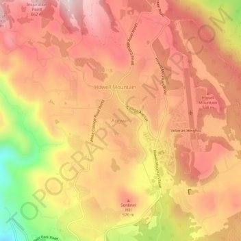
Name: Topografische Karte Angwin, Höhe, Relief.
Ort: Angwin, Napa County, California, 94508, United States (38.55574 -122.46998 38.59574 -122.42998)
Durchschnittliche Höhe: 517 m
Minimale Höhe: 235 m
Maximale Höhe: 669 m
Spenden
Rüsten Sie sich für Ihr nächstes Abenteuer:
Als Amazon-Partner erhält diese Website eine Provision für qualifizierte Käufe, ohne zusätzliche Kosten für Sie.
Andere topografische Karten
Klicken Sie auf eine Karte, um ihre Topografie, ihre Höhe und ihr Relief anzuzeigen.
Napa Valley AVA
United States > California > Napa County
Napa Valley's climate and geography are shaped by a unique cooling effect, crucial for premium grape growing. Originating from a cold ocean current from Alaska, this effect involves fog formation and cool air influx from the Pacific, offset by warmer air rising from California's Central Valley. This dynamic…
Durchschnittliche Höhe: 222 m
Spenden
Rüsten Sie sich für Ihr nächstes Abenteuer:
Als Amazon-Partner erhält diese Website eine Provision für qualifizierte Käufe, ohne zusätzliche Kosten für Sie.
Spenden
Rüsten Sie sich für Ihr nächstes Abenteuer:
Als Amazon-Partner erhält diese Website eine Provision für qualifizierte Käufe, ohne zusätzliche Kosten für Sie.
Napa Valley AVA
United States > California > Napa County
Napa Valley's climate and geography are shaped by a unique cooling effect, crucial for premium grape growing. Originating from a cold ocean current from Alaska, this effect involves fog formation and cool air influx from the Pacific, offset by warmer air rising from California's Central Valley. This dynamic…
Durchschnittliche Höhe: 222 m
Spenden
Rüsten Sie sich für Ihr nächstes Abenteuer:
Als Amazon-Partner erhält diese Website eine Provision für qualifizierte Käufe, ohne zusätzliche Kosten für Sie.