
Topografische Karte Hawkesbury
Interaktive Karte
Klicken Sie auf die Karte, um die Höhe anzuzeigen.
Über diese Karte
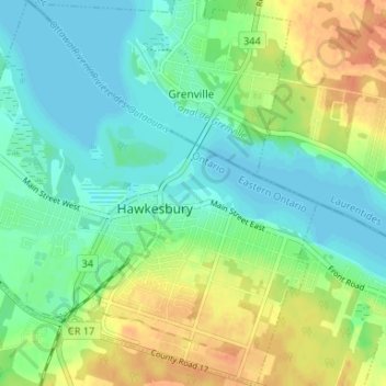
Name: Topografische Karte Hawkesbury, Höhe, Relief.
Durchschnittliche Höhe: 52 m
Minimale Höhe: 38 m
Maximale Höhe: 78 m
Andere topografische Karten
Klicken Sie auf eine Karte, um ihre Topografie, ihre Höhe und ihr Relief anzuzeigen.
Embrun
Canada > Ontario > Prescott and Russell Counties
Embrun, Russell, Prescott and Russell Counties, Eastern Ontario, Ontario, K0A 1W1, Canada
Durchschnittliche Höhe: 69 m
Alfred and Plantagenet
Canada > Ontario > Prescott and Russell Counties
Alfred and Plantagenet, Prescott and Russell Counties, Eastern Ontario, Ontario, Canada
Durchschnittliche Höhe: 71 m
Voyageur Provincial Park
Canada > Ontario > Prescott and Russell Counties > East Hawkesbury
Voyageur Provincial Park, East Hawkesbury, Prescott and Russell Counties, Eastern Ontario, Ontario, K0B 1B0, Canada
Durchschnittliche Höhe: 45 m
Limoges
Canada > Ontario > Prescott and Russell Counties > The Nation > Limoges
Limoges, The Nation, Prescott and Russell Counties, Eastern Ontario, Ontario, K0A 2M0, Canada
Durchschnittliche Höhe: 71 m
St-Eugène
Canada > Ontario > Prescott and Russell Counties > East Hawkesbury > St-Eugène
St-Eugène, East Hawkesbury, Prescott and Russell Counties, Eastern Ontario, Ontario, K0B 1P0, Canada
Durchschnittliche Höhe: 59 m
Clarence-Rockland
Canada > Ontario > Prescott and Russell Counties > Clarence-Rockland
Clarence-Rockland, Prescott and Russell Counties, Eastern Ontario, Ontario, Canada
Durchschnittliche Höhe: 71 m
The Nation
Canada > Ontario > Prescott and Russell Counties > The Nation
The Nation, Prescott and Russell Counties, Eastern Ontario, Ontario, Canada
Durchschnittliche Höhe: 72 m