
Topografische Karte Saint-Hilaire-de-Villefranche
Interaktive Karte
Klicken Sie auf die Karte, um die Höhe anzuzeigen.
Über diese Karte
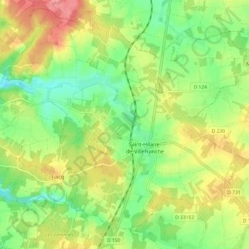
Name: Topografische Karte Saint-Hilaire-de-Villefranche, Höhe, Relief.
Durchschnittliche Höhe: 55 m
Minimale Höhe: 20 m
Maximale Höhe: 98 m
Andere topografische Karten
Klicken Sie auf eine Karte, um ihre Topografie, ihre Höhe und ihr Relief anzuzeigen.
Chez Dyon
France > Nouvelle-Aquitaine > Charente-Maritime > Saint-Hilaire-de-Villefranche
Chez Dyon, Saint-Hilaire-de-Villefranche, Saint-Jean-d'Angély, Charente-Maritime, Nouvelle-Aquitaine, France métropolitaine, 17770, France
Durchschnittliche Höhe: 55 m
Chez Chevroux
France > Nouvelle-Aquitaine > Charente-Maritime > Saint-Hilaire-de-Villefranche
Chez Chevroux, La Frédière, Saint-Hilaire-de-Villefranche, Saint-Jean-d'Angély, Charente-Maritime, Nouvelle-Aquitaine, France métropolitaine, 17770, France
Durchschnittliche Höhe: 43 m
Les Ormeaux
France > Nouvelle-Aquitaine > Charente-Maritime > Saint-Hilaire-de-Villefranche
Les Ormeaux, Saint-Hilaire-de-Villefranche, Saint-Jean-d'Angély, Charente-Maritime, Nouvelle-Aquitaine, France métropolitaine, 17770, France
Durchschnittliche Höhe: 55 m