
Topografische Karte Suez Canal
Interaktive Karte
Klicken Sie auf die Karte, um die Höhe anzuzeigen.
Über diese Karte
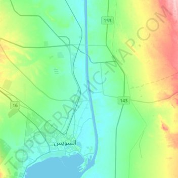
Name: Topografische Karte Suez Canal, Höhe, Relief.
Ort: Suez Canal, Suez, Egypt (29.92639 32.55958 30.16442 32.58845)
Durchschnittliche Höhe: 39 m
Minimale Höhe: -3 m
Maximale Höhe: 161 m
Despite the construction challenges that could have been the result of the alleged difference in sea levels, the idea of finding a shorter route to the east remained alive. In 1830, General Francis Chesney submitted a report to the British government that stated that there was no difference in elevation and that the Suez Canal was feasible, but his report received no further attention. Lieutenant Waghorn established his "Overland Route", which transported post and passengers to India via Egypt.
Andere topografische Karten
Klicken Sie auf eine Karte, um ihre Topografie, ihre Höhe und ihr Relief anzuzeigen.
Izbat Tall al Hajaj
Izbat Tall al Hajaj, Suez, 43515, Egypt
Durchschnittliche Höhe: 10 m