
Topografische Karte Diavolitsi
Interaktive Karte
Klicken Sie auf die Karte, um die Höhe anzuzeigen.
Über diese Karte
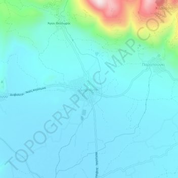
Name: Topografische Karte Diavolitsi, Höhe, Relief.
Durchschnittliche Höhe: 157 m
Minimale Höhe: 75 m
Maximale Höhe: 654 m
Andere topografische Karten
Klicken Sie auf eine Karte, um ihre Topografie, ihre Höhe und ihr Relief anzuzeigen.
Stoupa
Greece > Peloponnese, Western Greece and the Ionian > Messenia Regional Unit > Municipal Unit of Lefktro
Stoupa, Municipal Unit of Lefktro, Municipality of West Mani, Messenia Regional Unit, Peloponnese Region, Peloponnese, Western Greece and the Ionian, 240 24, Greece
Durchschnittliche Höhe: 63 m
Voreio
Greece > Peloponnese, Western Greece and the Ionian > Messenia Regional Unit > Municipal Unit of Avia
Voreio, Municipal Unit of Avia, Municipality of West Mani, Messenia Regional Unit, Peloponnese Region, Peloponnese, Western Greece and the Ionian, 240 16, Greece
Durchschnittliche Höhe: 668 m
Palace of Nestor
Greece > Peloponnese, Western Greece and the Ionian > Messenia Regional Unit > Chora > Pisaski
Palace of Nestor, Old National Highway 9, Pisaski, Chora, Municipality of Pylos and Nestor, Messenia Regional Unit, Peloponnese Region, Peloponnese, Western Greece and the Ionian, 246 00, Greece
Durchschnittliche Höhe: 146 m
Municipality of Pylos and Nestor
Greece > Peloponnese, Western Greece and the Ionian > Messenia Regional Unit
Municipality of Pylos and Nestor, Messenia Regional Unit, Peloponnese Region, Peloponnese, Western Greece and the Ionian, Greece
Durchschnittliche Höhe: 101 m
Καλαμάκι
Greece > Peloponnese, Western Greece and the Ionian > Messenia Regional Unit
Καλαμάκι, Municipality of Pylos and Nestor, Messenia Regional Unit, Peloponnese Region, Peloponnese, Western Greece and the Ionian, Greece
Durchschnittliche Höhe: 344 m
Exochori
Greece > Peloponnese, Western Greece and the Ionian > Messenia Regional Unit > Municipal Unit of Lefktro
Exochori, Municipal Unit of Lefktro, Municipality of West Mani, Messenia Regional Unit, Peloponnese Region, Peloponnese, Western Greece and the Ionian, 240 22, Greece
Durchschnittliche Höhe: 501 m
Pylos
Greece > Peloponnese, Western Greece and the Ionian > Messenia Regional Unit
Pylos, Municipality of Pylos and Nestor, Messenia Regional Unit, Peloponnese Region, Peloponnese, Western Greece and the Ionian, 240 01, Greece
Durchschnittliche Höhe: 79 m
Κυπαρισσία
Greece > Peloponnese, Western Greece and the Ionian > Messenia Regional Unit > Kyparissia Municipal Unit > Κυπαρισσία
Κυπαρισσία, Kyparissia Municipal Unit, Municipality of Trifylia, Messenia Regional Unit, Peloponnese Region, Peloponnese, Western Greece and the Ionian, 24500, Greece
Durchschnittliche Höhe: 152 m
Municipality of Kalamata
Greece > Peloponnese, Western Greece and the Ionian > Messenia Regional Unit
Municipality of Kalamata, Messenia Regional Unit, Peloponnese Region, Peloponnese, Western Greece and the Ionian, Greece
Durchschnittliche Höhe: 490 m