
Spenden
Rüsten Sie sich für Ihr nächstes Abenteuer:
Als Amazon-Partner erhält diese Website eine Provision für qualifizierte Käufe, ohne zusätzliche Kosten für Sie.
Topografische Karte Panama City Beach
Klicken Sie auf die Karte, um die Höhe anzuzeigen.
Spenden
Rüsten Sie sich für Ihr nächstes Abenteuer:
Als Amazon-Partner erhält diese Website eine Provision für qualifizierte Käufe, ohne zusätzliche Kosten für Sie.
Panama City Beach
Panama City Beach, located in Bay County, Florida, features a predominantly flat topography typical of coastal areas. Its terrain is characterized by low elevations, generally ranging between 20 to 30 feet (6 to 9 meters) above sea level. This flatness is interrupted by occasional sand dunes that rise up along the shore, contributing to the region’s scenic beachfront. The city lies along the Gulf of Mexico, with the Gulf Lagoon and St. Andrews Bay nearby, creating a unique environment of sandy stretches and shallow waters. The area’s terrain is ideal for beach activities and is shaped by both natural processes and human development. The land is part of the larger Gulf Coastal Plain, offering expansive views and easy access to water from almost any point in the region.
Spenden
Rüsten Sie sich für Ihr nächstes Abenteuer:
Als Amazon-Partner erhält diese Website eine Provision für qualifizierte Käufe, ohne zusätzliche Kosten für Sie.
Über diese Karte
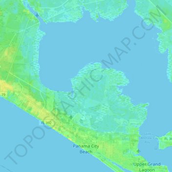
Name: Topografische Karte Panama City Beach, Höhe, Relief.
Ort: Panama City Beach, Bay County, Florida, United States (30.16509 -85.95800 30.29679 -85.78590)
Durchschnittliche Höhe: 2 m
Minimale Höhe: -2 m
Maximale Höhe: 17 m
Spenden
Rüsten Sie sich für Ihr nächstes Abenteuer:
Als Amazon-Partner erhält diese Website eine Provision für qualifizierte Käufe, ohne zusätzliche Kosten für Sie.
Andere topografische Karten
Klicken Sie auf eine Karte, um ihre Topografie, ihre Höhe und ihr Relief anzuzeigen.
Spenden
Rüsten Sie sich für Ihr nächstes Abenteuer:
Als Amazon-Partner erhält diese Website eine Provision für qualifizierte Käufe, ohne zusätzliche Kosten für Sie.
Spenden
Rüsten Sie sich für Ihr nächstes Abenteuer:
Als Amazon-Partner erhält diese Website eine Provision für qualifizierte Käufe, ohne zusätzliche Kosten für Sie.
Gulf Resort Beach
United States > Florida > Bay County > Panama City Beach
Durchschnittliche Höhe: 5 m
Spenden
Rüsten Sie sich für Ihr nächstes Abenteuer:
Als Amazon-Partner erhält diese Website eine Provision für qualifizierte Käufe, ohne zusätzliche Kosten für Sie.