
Spenden
Rüsten Sie sich für Ihr nächstes Abenteuer:
Als Amazon-Partner erhält diese Website eine Provision für qualifizierte Käufe, ohne zusätzliche Kosten für Sie.
Topografische Karte Orangevale
Klicken Sie auf die Karte, um die Höhe anzuzeigen.
Spenden
Rüsten Sie sich für Ihr nächstes Abenteuer:
Als Amazon-Partner erhält diese Website eine Provision für qualifizierte Käufe, ohne zusätzliche Kosten für Sie.
Über diese Karte
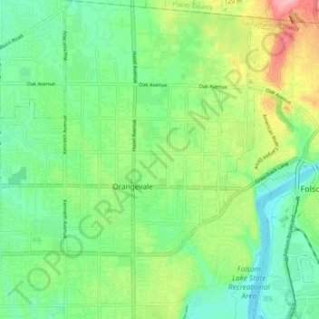
Name: Topografische Karte Orangevale, Höhe, Relief.
Durchschnittliche Höhe: 74 m
Minimale Höhe: 35 m
Maximale Höhe: 149 m
Spenden
Rüsten Sie sich für Ihr nächstes Abenteuer:
Als Amazon-Partner erhält diese Website eine Provision für qualifizierte Käufe, ohne zusätzliche Kosten für Sie.
Andere topografische Karten
Klicken Sie auf eine Karte, um ihre Topografie, ihre Höhe und ihr Relief anzuzeigen.
Carmichael
United States > California > Sacramento County > Citrus Heights
Durchschnittliche Höhe: 35 m
Spenden
Rüsten Sie sich für Ihr nächstes Abenteuer:
Als Amazon-Partner erhält diese Website eine Provision für qualifizierte Käufe, ohne zusätzliche Kosten für Sie.
William B. Pond Recreation Area
United States > California > Sacramento County
Durchschnittliche Höhe: 21 m
Tiscornia Park
United States > California > Sacramento County > Sacramento
Durchschnittliche Höhe: 9 m
Walnut Grove
United States > California > Sacramento County
Walnut Grove's location has made it the site of a rare collection of very tall radio and television transmission towers. The first major tower here was the KXTV/KOVR/KCRA Tower built in 1962, which dominated the skyline for over twenty years with its 1,548 foot height. In 1985 the old tower was joined by…
Durchschnittliche Höhe: 1 m
Spenden
Rüsten Sie sich für Ihr nächstes Abenteuer:
Als Amazon-Partner erhält diese Website eine Provision für qualifizierte Käufe, ohne zusätzliche Kosten für Sie.
Spenden
Rüsten Sie sich für Ihr nächstes Abenteuer:
Als Amazon-Partner erhält diese Website eine Provision für qualifizierte Käufe, ohne zusätzliche Kosten für Sie.
Natomas Main Drainage Canal
United States > California > Sacramento County > Sacramento
Durchschnittliche Höhe: 7 m
Spenden
Rüsten Sie sich für Ihr nächstes Abenteuer:
Als Amazon-Partner erhält diese Website eine Provision für qualifizierte Käufe, ohne zusätzliche Kosten für Sie.
Spenden
Rüsten Sie sich für Ihr nächstes Abenteuer:
Als Amazon-Partner erhält diese Website eine Provision für qualifizierte Käufe, ohne zusätzliche Kosten für Sie.
Del Paso Heights
United States > California > Sacramento County > Sacramento
Durchschnittliche Höhe: 18 m
Spenden
Rüsten Sie sich für Ihr nächstes Abenteuer:
Als Amazon-Partner erhält diese Website eine Provision für qualifizierte Käufe, ohne zusätzliche Kosten für Sie.
North Sacramento
United States > California > Sacramento County > Sacramento
Durchschnittliche Höhe: 11 m
Carmichael
United States > California > Sacramento County > Citrus Heights
Durchschnittliche Höhe: 35 m
Spenden
Rüsten Sie sich für Ihr nächstes Abenteuer:
Als Amazon-Partner erhält diese Website eine Provision für qualifizierte Käufe, ohne zusätzliche Kosten für Sie.
Wilton
United States > California > Sacramento County > Elk Grove > Wilton
Durchschnittliche Höhe: 23 m
Spenden
Rüsten Sie sich für Ihr nächstes Abenteuer:
Als Amazon-Partner erhält diese Website eine Provision für qualifizierte Käufe, ohne zusätzliche Kosten für Sie.
Detention Pond
United States > California > Sacramento County > Sacramento
Durchschnittliche Höhe: 5 m
Rancho Murieta
United States > California > Sacramento County > Rancho Murieta
Durchschnittliche Höhe: 91 m
Spenden
Rüsten Sie sich für Ihr nächstes Abenteuer:
Als Amazon-Partner erhält diese Website eine Provision für qualifizierte Käufe, ohne zusätzliche Kosten für Sie.
Wild Rose Park
United States > California > Sacramento County > Sacramento
Durchschnittliche Höhe: 7 m
Spenden
Rüsten Sie sich für Ihr nächstes Abenteuer:
Als Amazon-Partner erhält diese Website eine Provision für qualifizierte Käufe, ohne zusätzliche Kosten für Sie.