
Topografische Karte Qu'Appelle
Interaktive Karte
Klicken Sie auf die Karte, um die Höhe anzuzeigen.
Über diese Karte
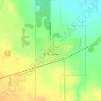
Name: Topografische Karte Qu'Appelle, Höhe, Relief.
Ort: Qu'Appelle, Division No. 6, Saskatchewan, S0G 4A0, Canada (50.52776 -103.88483 50.55699 -103.86206)
Durchschnittliche Höhe: 651 m
Minimale Höhe: 633 m
Maximale Höhe: 665 m
Qu'Appelle is located in the Indian Head Plain of the Aspen Parkland ecoregion on the parkland of the Qu'Appelle flood plain. Qu'Appelle's elevation is 662.90 m (2,174.9 ft) above sea level. The area is characterised by lush rolling grasslands, interspersed with poplar bluffs (in prairie Canadian terminology poplar groves surrounding sloughs) and open sloughs. Qu'Appelle is located in the transition zone between the Qu'Appelle River and the corresponding Qu'Appelle Valley and the Canadian Prairies.
Andere topografische Karten
Klicken Sie auf eine Karte, um ihre Topografie, ihre Höhe und ihr Relief anzuzeigen.
Sorenson's Beach
Canada > Saskatchewan > Division No. 6 > McKillop No. 220
Sorenson's Beach, McKillop No. 220, Division No. 6, Saskatchewan, Canada
Durchschnittliche Höhe: 507 m
Lumsden
Canada > Saskatchewan > Division No. 6
Lumsden, Division No. 6, Saskatchewan, S0G 3C0, Canada
Durchschnittliche Höhe: 527 m
Fort Qu'Appelle
Canada > Saskatchewan > Division No. 6
Fort Qu'Appelle, Division No. 6, Saskatchewan, S0G 1S0, Canada
Durchschnittliche Höhe: 497 m
Southey
Canada > Saskatchewan > Division No. 6
Southey, Division No. 6, Saskatchewan, S0G 4P0, Canada
Durchschnittliche Höhe: 559 m
Regina
Canada > Saskatchewan > Division No. 6
Regina, Division No. 6, Saskatchewan, Canada
Durchschnittliche Höhe: 582 m