
Topografische Karte Danbury
Interaktive Karte
Klicken Sie auf die Karte, um die Höhe anzuzeigen.
Danbury
The highest point in Danbury is the summit of Tinkham Hill, at 2,320 feet (710 m) above sea level, in the northern part of town. Ragged Mountain is a prominent mountain with multiple summits which occupies the southern portion of town and has a ski area of the same name; the elevation of the Danbury summit of Ragged is 2,225 ft (678 m) above sea level. The Sunapee-Ragged-Kearsarge Greenway hiking trail crosses a corner of Danbury along Ragged Mountain's Ridge Trail. Access to the Ridge Trail from the SRK Greenway is on the SRKG 6.1 mile trail section 9, either from trailhead parking on New Canada Road in Wilmot from the northwest or from Proctor Academy's trailhead parking in Andover from the southeast.
Über diese Karte
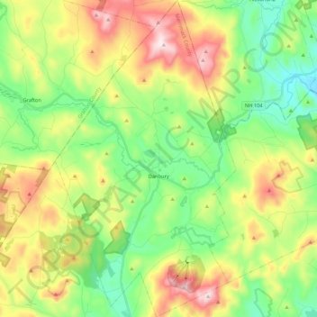
Name: Topografische Karte Danbury, Höhe, Relief.
Durchschnittliche Höhe: 349 m
Minimale Höhe: 138 m
Maximale Höhe: 700 m
Andere topografische Karten
Klicken Sie auf eine Karte, um ihre Topografie, ihre Höhe und ihr Relief anzuzeigen.
Rattlesnake Hill
United States > New Hampshire > Merrimack County > Concord
Durchschnittliche Höhe: 148 m
Webster Mills
United States > New Hampshire > Merrimack County > Pittsfield
Durchschnittliche Höhe: 168 m
Mount Kearsarge
United States > New Hampshire > Merrimack County > Wilmot
Durchschnittliche Höhe: 607 m
Shaker Village
United States > New Hampshire > Merrimack County > Canterbury
Durchschnittliche Höhe: 205 m
Rings Corner
United States > New Hampshire > Merrimack County > Pittsfield > Rings Corner
Durchschnittliche Höhe: 190 m