
Topografische Karte Bookpurnong
Interaktive Karte
Klicken Sie auf die Karte, um die Höhe anzuzeigen.
Über diese Karte
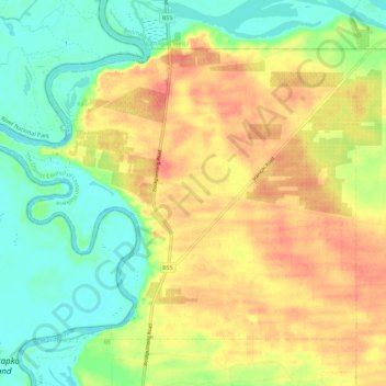
Name: Topografische Karte Bookpurnong, Höhe, Relief.
Durchschnittliche Höhe: 37 m
Minimale Höhe: 9 m
Maximale Höhe: 66 m
Andere topografische Karten
Klicken Sie auf eine Karte, um ihre Topografie, ihre Höhe und ihr Relief anzuzeigen.
Ramco
Australia > South Australia > The District Council of Loxton Waikerie
Ramco, The District Council of Loxton Waikerie, South Australia, 5322, Australia
Durchschnittliche Höhe: 29 m
Loxton
Australia > South Australia > The District Council of Loxton Waikerie > Loxton
Loxton, The District Council of Loxton Waikerie, South Australia, 5333, Australia
Durchschnittliche Höhe: 37 m
Loxton North
Australia > South Australia > The District Council of Loxton Waikerie
Loxton North, The District Council of Loxton Waikerie, South Australia, 5333, Australia
Durchschnittliche Höhe: 37 m