
Topografische Karte Cornwall (Connecticut)
Interaktive Karte
Klicken Sie auf die Karte, um die Höhe anzuzeigen.
Über diese Karte
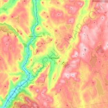
Name: Topografische Karte Cornwall (Connecticut), Höhe, Relief.
Durchschnittliche Höhe: 344 m
Minimale Höhe: 122 m
Maximale Höhe: 506 m
Andere topografische Karten
Klicken Sie auf eine Karte, um ihre Topografie, ihre Höhe und ihr Relief anzuzeigen.
Corner of the Pines
États-Unis d'Amérique > Connecticut > Litchfield County > Cornwall (Connecticut) > Corner of the Pines
Durchschnittliche Höhe: 304 m