
Spenden
Rüsten Sie sich für Ihr nächstes Abenteuer:
Als Amazon-Partner erhält diese Website eine Provision für qualifizierte Käufe, ohne zusätzliche Kosten für Sie.
Topografische Karte Blood Mountain
Klicken Sie auf die Karte, um die Höhe anzuzeigen.
Spenden
Rüsten Sie sich für Ihr nächstes Abenteuer:
Als Amazon-Partner erhält diese Website eine Provision für qualifizierte Käufe, ohne zusätzliche Kosten für Sie.
Blood Mountain
Blood Mountain is the highest peak on the Georgia section of the Appalachian Trail and the sixth-tallest mountain in Georgia, with an elevation of 4,458 feet (1,359 m). It is located on the border of Lumpkin County with Union County and is within the boundaries of the Chattahoochee National Forest and the Blood Mountain Wilderness. There are several waterfalls, hiking trails and other recreational areas in the vicinity. This mountain marks the southernmost range limit for many Northern and Appalachian species, especially for plant species.
Spenden
Rüsten Sie sich für Ihr nächstes Abenteuer:
Als Amazon-Partner erhält diese Website eine Provision für qualifizierte Käufe, ohne zusätzliche Kosten für Sie.
Über diese Karte
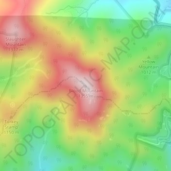
Name: Topografische Karte Blood Mountain, Höhe, Relief.
Ort: Blood Mountain, Union County, Georgia, United States (34.73966 -83.93707 34.73976 -83.93697)
Durchschnittliche Höhe: 1.048 m
Minimale Höhe: 795 m
Maximale Höhe: 1.338 m
Spenden
Rüsten Sie sich für Ihr nächstes Abenteuer:
Als Amazon-Partner erhält diese Website eine Provision für qualifizierte Käufe, ohne zusätzliche Kosten für Sie.
Andere topografische Karten
Klicken Sie auf eine Karte, um ihre Topografie, ihre Höhe und ihr Relief anzuzeigen.
Blairsville
United States > Georgia > Union County
Blairsville, Georgia, is situated in the picturesque Appalachian Mountains, characterized by a varied topography that includes rolling hills, lush valleys, and prominent mountain ridges. The elevation of the town itself is approximately 1,800 feet, providing breathtaking views of the surrounding landscape. The…
Durchschnittliche Höhe: 587 m
Blairsville
United States > Georgia > Union County
Blairsville has a humid subtropical climate, yet due to its elevation of 1,883 feet (574 m), typically records far lower temperatures at night than what is encountered in much of the Southeastern U.S., and has slightly higher precipitation totals (56 inches or 1,420 millimetres annually) than most locations in…
Durchschnittliche Höhe: 587 m