
Topografische Karte Bargas
Interaktive Karte
Klicken Sie auf die Karte, um die Höhe anzuzeigen.
Über diese Karte
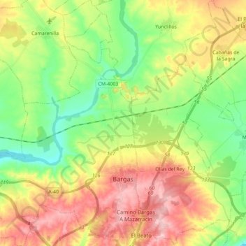
Name: Topografische Karte Bargas, Höhe, Relief.
Ort: Bargas, La Sagra, Toledo, Castilla-La Mancha, 45593, España (39.90319 -4.17017 40.03533 -4.00878)
Durchschnittliche Höhe: 532 m
Minimale Höhe: 456 m
Maximale Höhe: 631 m
Andere topografische Karten
Klicken Sie auf eine Karte, um ihre Topografie, ihre Höhe und ihr Relief anzuzeigen.
Illescas
España > Castilla-La Mancha > La Sagra
Illescas, La Sagra, Toledo, Castilla-La Mancha, 45200, España
Durchschnittliche Höhe: 602 m
Magán
España > Castilla-La Mancha > La Sagra
Magán, La Sagra, Toledo, Castilla-La Mancha, España
Durchschnittliche Höhe: 505 m