
Topografische Karte Cascade
Interaktive Karte
Klicken Sie auf die Karte, um die Höhe anzuzeigen.
Über diese Karte
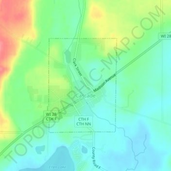
Name: Topografische Karte Cascade, Höhe, Relief.
Ort: Cascade, Sheboygan County, Wisconsin, United States (43.65247 -88.01539 43.66734 -88.00025)
Durchschnittliche Höhe: 276 m
Minimale Höhe: 251 m
Maximale Höhe: 327 m
Andere topografische Karten
Klicken Sie auf eine Karte, um ihre Topografie, ihre Höhe und ihr Relief anzuzeigen.
Town of Plymouth
United States > Wisconsin > Sheboygan County
Town of Plymouth, Sheboygan County, Wisconsin, United States
Durchschnittliche Höhe: 257 m
Cedar Grove
United States > Wisconsin > Sheboygan County
Cedar Grove, Sheboygan County, Wisconsin, 53013, United States
Durchschnittliche Höhe: 216 m
Plymouth
United States > Wisconsin > Sheboygan County
Plymouth, Sheboygan County, Wisconsin, 53073, United States
Durchschnittliche Höhe: 265 m
Sheboygan
United States > Wisconsin > Sheboygan County > Sheboygan
Sheboygan, Sheboygan County, Wisconsin, 53081, United States
Durchschnittliche Höhe: 188 m
Random Lake
United States > Wisconsin > Sheboygan County
Random Lake, Sheboygan County, Wisconsin, 53075, United States
Durchschnittliche Höhe: 272 m
Town of Scott
United States > Wisconsin > Sheboygan County
Town of Scott, Sheboygan County, Wisconsin, 53001, United States
Durchschnittliche Höhe: 291 m
Elkhart Lake
United States > Wisconsin > Sheboygan County
Elkhart Lake, Sheboygan County, Wisconsin, United States
Durchschnittliche Höhe: 289 m
Kohler
United States > Wisconsin > Sheboygan County > Kohler
Kohler, Sheboygan County, Wisconsin, 53044, United States
Durchschnittliche Höhe: 205 m
Adell
United States > Wisconsin > Sheboygan County > Adell
Adell, Sheboygan County, Wisconsin, United States
Durchschnittliche Höhe: 278 m