
Topografische Karte Ghandiyal
Klicken Sie auf die Karte, um die Höhe anzuzeigen.
Über diese Karte
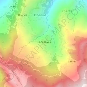
Name: Topografische Karte Ghandiyal, Höhe, Relief.
Ort: Ghandiyal, Karnaprayag, Chamoli district, Uttarakhand, India (30.16943 79.25438 30.17349 79.25687)
Durchschnittliche Höhe: 1.748 m
Minimale Höhe: 1.278 m
Maximale Höhe: 2.190 m
Andere topografische Karten
Klicken Sie auf eine Karte, um ihre Topografie, ihre Höhe und ihr Relief anzuzeigen.
Karnaprayag
India > Uttarakhand > Karnaprayag
Karnaprayag is located at 30°16′N 79°15′E / 30.27°N 79.25°E / 30.27; 79.25. It has an average elevation of 860 metres (2,820 feet). The confluence of the Pindar River, which arises from the icy Pindari glacier and the Alaknanda, occurs at Karnaprayag. Nanda Devi, towering above at 7,816 m…
Durchschnittliche Höhe: 1.273 m