
Topografische Karte Stone Mills
Interaktive Karte
Klicken Sie auf die Karte, um die Höhe anzuzeigen.
Über diese Karte
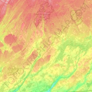
Name: Topografische Karte Stone Mills, Höhe, Relief.
Durchschnittliche Höhe: 164 m
Minimale Höhe: 86 m
Maximale Höhe: 254 m
Andere topografische Karten
Klicken Sie auf eine Karte, um ihre Topografie, ihre Höhe und ihr Relief anzuzeigen.
Desmond
Canada > Ontario > Lennox and Addington County > Stone Mills
Desmond, Stone Mills, Lennox and Addington County, Eastern Ontario, Ontario, Canada
Durchschnittliche Höhe: 148 m
Winter Road Lake
Canada > Ontario > Lennox and Addington County > Addington Highlands
Winter Road Lake, Addington Highlands, Lennox and Addington County, Eastern Ontario, Ontario, Canada
Durchschnittliche Höhe: 386 m
Yarker
Canada > Ontario > Lennox and Addington County > Stone Mills
Yarker, Stone Mills, Lennox and Addington County, Eastern Ontario, Ontario, K0K 3N0, Canada
Durchschnittliche Höhe: 152 m