
Topografische Karte Fort Payne
Interaktive Karte
Klicken Sie auf die Karte, um die Höhe anzuzeigen.
Über diese Karte
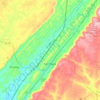
Name: Topografische Karte Fort Payne, Höhe, Relief.
Ort: Fort Payne, DeKalb County, Alabama, 35967, United States (34.37007 -85.78068 34.53943 -85.60399)
Durchschnittliche Höhe: 369 m
Minimale Höhe: 220 m
Maximale Höhe: 556 m
Andere topografische Karten
Klicken Sie auf eine Karte, um ihre Topografie, ihre Höhe und ihr Relief anzuzeigen.
Pine Ridge
United States > Alabama > DeKalb County
Pine Ridge, DeKalb County, Alabama, United States
Durchschnittliche Höhe: 312 m
Mount Brandon
United States > Alabama > DeKalb County
Mount Brandon, DeKalb County, Alabama, United States
Durchschnittliche Höhe: 419 m
Wooten Hill
United States > Alabama > DeKalb County
Wooten Hill, DeKalb County, Alabama, United States
Durchschnittliche Höhe: 387 m
Mentone
United States > Alabama > DeKalb County > Mentone
Mentone, DeKalb County, Alabama, 35984, United States
Durchschnittliche Höhe: 470 m
Shiloh
United States > Alabama > DeKalb County > Shiloh
Shiloh, DeKalb County, Alabama, United States
Durchschnittliche Höhe: 378 m