
Topografische Karte Smith Brook
Interaktive Karte
Klicken Sie auf die Karte, um die Höhe anzuzeigen.
Über diese Karte
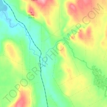
Name: Topografische Karte Smith Brook, Höhe, Relief.
Durchschnittliche Höhe: 244 m
Minimale Höhe: 194 m
Maximale Höhe: 316 m
Andere topografische Karten
Klicken Sie auf eine Karte, um ihre Topografie, ihre Höhe und ihr Relief anzuzeigen.
Gilead
United States of America > Maine > Gilead
Gilead, Oxford County, Maine, United States of America
Durchschnittliche Höhe: 325 m
Rockland
United States of America > Maine > Rockland
Rockland, Knox County, Maine, 04841, United States of America
Durchschnittliche Höhe: 37 m
South China
United States of America > Maine > South China
South China, Kennebec County, Maine, 04358, United States of America
Durchschnittliche Höhe: 78 m
Wreck Island
United States of America > Maine
Wreck Island, Lincoln County, Maine, United States of America
Durchschnittliche Höhe: 0 m
Kingfield
United States of America > Maine > Kingfield
Kingfield, Franklin County, Maine, United States of America
Durchschnittliche Höhe: 294 m
Jones Hill
United States of America > Maine
Jones Hill, Cumberland County, Maine, United States of America
Durchschnittliche Höhe: 75 m
Jobs Mountain
United States of America > Maine
Jobs Mountain, Waldo County, Maine, 04848, United States of America
Durchschnittliche Höhe: 10 m
Mount David
United States of America > Maine > Lewiston
Mount David, Lewiston, Androscoggin County, Maine, 04240, United States of America
Durchschnittliche Höhe: 68 m
Remick Corners
United States of America > Maine > Kittery > Remick Corners
Remick Corners, Kittery, York County, Maine, 03904, United States of America
Durchschnittliche Höhe: 10 m
Westbrook
United States of America > Maine > Westbrook
Westbrook, Cumberland County, Maine, United States of America
Durchschnittliche Höhe: 41 m
Brown Mountain
United States of America > Maine
Brown Mountain, Oxford County, Maine, United States of America
Durchschnittliche Höhe: 403 m
Churchill Island
United States of America > Maine
Churchill Island, Aroostook County, Maine, 04738, United States of America
Durchschnittliche Höhe: 205 m