
Topografische Karte Browns Lake/IPS Wildlife Management Area
Interaktive Karte
Klicken Sie auf die Karte, um die Höhe anzuzeigen.
Über diese Karte
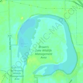
Name: Topografische Karte Browns Lake/IPS Wildlife Management Area, Höhe, Relief.
Durchschnittliche Höhe: 328 m
Minimale Höhe: 322 m
Maximale Höhe: 338 m
Andere topografische Karten
Klicken Sie auf eine Karte, um ihre Topografie, ihre Höhe und ihr Relief anzuzeigen.
Glenwood
United States of America > Iowa > Glenwood
Glenwood, Mills County, Iowa, 51534, United States of America
Durchschnittliche Höhe: 327 m
Key West
United States of America > Iowa > Key West
Key West, Dubuque County, Iowa, 52003, United States of America
Durchschnittliche Höhe: 233 m
Osborne
United States of America > Iowa > Osborne
Osborne, Clayton County, Iowa, United States of America
Durchschnittliche Höhe: 269 m
Volga River
United States of America > Iowa
Volga River, Clayton County, Iowa, 52055, United States of America
Durchschnittliche Höhe: 268 m
Montezuma
United States of America > Iowa > Montezuma
Montezuma, Poweshiek County, Iowa, 50171, United States of America
Durchschnittliche Höhe: 284 m
Inwood
United States of America > Iowa > Inwood
Inwood, Lyon County, Iowa, United States of America
Durchschnittliche Höhe: 444 m
Durant
United States of America > Iowa > Durant
Durant, Cedar County, Iowa, 552747, United States of America
Durchschnittliche Höhe: 215 m
Griswold
United States of America > Iowa > Griswold
Griswold, Cass County, Iowa, United States of America
Durchschnittliche Höhe: 336 m
Milton
United States of America > Iowa > Milton
Milton, Iowa, United States of America
Durchschnittliche Höhe: 239 m
Hartwick
United States of America > Iowa > Hartwick > Hartwick
Hartwick, Poweshiek County, Iowa, 52232, United States of America
Durchschnittliche Höhe: 278 m
Burr Oak
United States of America > Iowa > Burr Oak > Burr Oak
Burr Oak, Winneshiek County, Iowa, United States of America
Durchschnittliche Höhe: 384 m