
Topografische Karte Florida
Interaktive Karte
Klicken Sie auf die Karte, um die Höhe anzuzeigen.
Über diese Karte
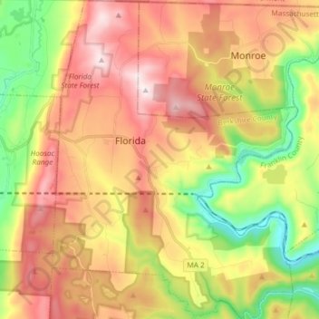
Name: Topografische Karte Florida, Höhe, Relief.
Durchschnittliche Höhe: 525 m
Minimale Höhe: 189 m
Maximale Höhe: 859 m
Florida is a town in Berkshire County, Massachusetts, United States. It is part of the Pittsfield, Massachusetts Metropolitan Statistical Area. It is home to the east portal of the Hoosac Tunnel, as well as Whitcomb Summit (elevation 2,172 ft or 662 m), the highest point of the Mohawk Trail. Florida contains the village of Drury. At the 2010 census the town had a total population of 752.