
Topografische Karte Nazareth
Interaktive Karte
Klicken Sie auf die Karte, um die Höhe anzuzeigen.
Über diese Karte
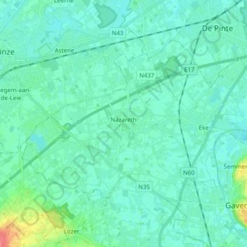
Name: Topografische Karte Nazareth, Höhe, Relief.
Ort: Nazareth, East Flanders, Flanders, 9810, Belgium (50.92849 3.53860 50.98828 3.67853)
Durchschnittliche Höhe: 10 m
Minimale Höhe: 2 m
Maximale Höhe: 52 m
As of the early 1990s, no city plans drafted by Nazareth Municipality have been approved by the government (both the British Mandate and later Israel) since 1942. This has left many people in Nazareth who vote in the city's municipal elections and receive services from its municipality effectively outside of the city's jurisdiction. Such areas include the Sharqiya and Jabal el-Daula quarters which are in Nazareth Illit's jurisdiction and whose residents had to acquire building permits from the latter city. Similarly, the Bilal neighborhood of the Safafra Quarter is located within Reineh's jurisdiction. In 1993, the residents of Bilal became official residents of Reineh. Nazareth's municipal plans for expansion prior to the establishment of Nazareth Illit, were to the north and east, areas that the latter city now occupy. Arab satellite towns are closely located to the north, west and southwest. Thus, the remaining area within the city's municipal boundaries available for expansion were to the northwest and the south, where the topography restricted urban development. After lobbying the Knesset and the Interior Ministry, el-Zoubi was able to have areas to the northwest of the city annexed to the municipality.