
Topografische Karte Bois-de-Villers
Interaktive Karte
Klicken Sie auf die Karte, um die Höhe anzuzeigen.
Über diese Karte
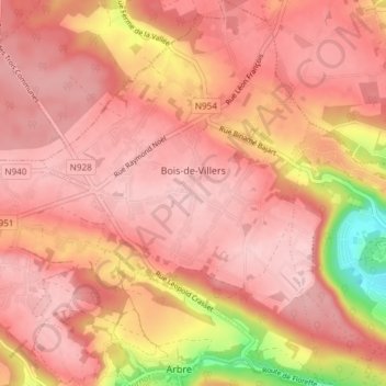
Name: Topografische Karte Bois-de-Villers, Höhe, Relief.
Ort: Bois-de-Villers, Profondeville, Namur, Wallonie, 5170, Belgique (50.36341 4.79421 50.41090 4.84882)
Durchschnittliche Höhe: 223 m
Minimale Höhe: 89 m
Maximale Höhe: 270 m
Andere topografische Karten
Klicken Sie auf eine Karte, um ihre Topografie, ihre Höhe und ihr Relief anzuzeigen.
Profondeville
Belgique > Namur > Namur > Profondeville
Profondeville, Namur, Wallonie, 5160, Belgique
Durchschnittliche Höhe: 171 m
Lustin
Belgique > Namur > Namur > Profondeville
Lustin, Profondeville, Namur, Wallonie, Belgique
Durchschnittliche Höhe: 199 m