
Topografische Karte Distrito Ciudad de Luján de Cuyo
Interaktive Karte
Klicken Sie auf die Karte, um die Höhe anzuzeigen.
Distrito Ciudad de Luján de Cuyo
Situated in the upper Mendoza valley, where the river is half-way through its journey from the Andes mountains to the eastern plains, many Lujan de Cuyo vineyards sit at altitudes of around 1000 m (3280 ft). Malbec in particular is successful in Lujan de Cuyo, but the appellation also produces good Cabernet Sauvignon, Chardonnay and Torrontes. The majority of the vineyards are on alluvial soils; sandy or stony surfaces on clay substrata.
Über diese Karte
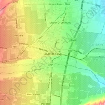
Name: Topografische Karte Distrito Ciudad de Luján de Cuyo, Höhe, Relief.
Durchschnittliche Höhe: 949 m
Minimale Höhe: 888 m
Maximale Höhe: 1.033 m
Andere topografische Karten
Klicken Sie auf eine Karte, um ihre Topografie, ihre Höhe und ihr Relief anzuzeigen.
Luján de Cuyo
Argentina > Mendoza > Departamento Luján de Cuyo > Luján de Cuyo
Durchschnittliche Höhe: 943 m