
Topografische Karte Dinapur-Cum-Khagaul
Interaktive Karte
Klicken Sie auf die Karte, um die Höhe anzuzeigen.
Über diese Karte
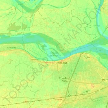
Name: Topografische Karte Dinapur-Cum-Khagaul, Höhe, Relief.
Ort: Dinapur-Cum-Khagaul, Patna District, Bihar, India (25.56629 84.97998 25.73202 85.10694)
Durchschnittliche Höhe: 51 m
Minimale Höhe: 39 m
Maximale Höhe: 62 m
Andere topografische Karten
Klicken Sie auf eine Karte, um ihre Topografie, ihre Höhe und ihr Relief anzuzeigen.
West Champaran District
West Champaran District, Bihar, India
Durchschnittliche Höhe: 132 m
Forbesganj
India > Bihar > Forbesganj
Forbesganj, Araria, Bihar, 854318, India
Durchschnittliche Höhe: 61 m
Manikpur
India > Bihar > Narpatganj > Manikpur
Manikpur, Narpatganj, Araria, Bihar, 854336, India
Durchschnittliche Höhe: 70 m
Gaya
India > Bihar > Gaya Town C.D.Block > Gaya
Gaya, Gaya Town C.D.Block, Gaya, Bihar, 823001, India
Durchschnittliche Höhe: 111 m