
Topografische Karte Municipal Unit of Nikaia
Interaktive Karte
Klicken Sie auf die Karte, um die Höhe anzuzeigen.
Über diese Karte
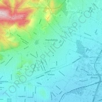
Name: Topografische Karte Municipal Unit of Nikaia, Höhe, Relief.
Durchschnittliche Höhe: 95 m
Minimale Höhe: 5 m
Maximale Höhe: 458 m
Andere topografische Karten
Klicken Sie auf eine Karte, um ihre Topografie, ihre Höhe und ihr Relief anzuzeigen.
Keratsini
Greece > Attica > Regional Unit of Piraeus > Municipal Unit of Keratsini
Keratsini, Municipal Unit of Keratsini, Municipality of Keratsini-Drapetsona, Regional Unit of Piraeus, Attica, 187 56, Greece
Durchschnittliche Höhe: 73 m
Piraeus
Greece > Attica > Regional Unit of Piraeus
Piraeus, Municipality of Piraeus, Regional Unit of Piraeus, Attica, 185 35, Greece
Durchschnittliche Höhe: 96 m