
Topografische Karte Amravati
Interaktive Karte
Klicken Sie auf die Karte, um die Höhe anzuzeigen.
Über diese Karte
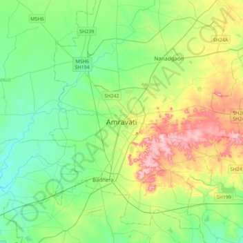
Name: Topografische Karte Amravati, Höhe, Relief.
Ort: Amravati, Maharashtra, 444600, India (20.77162 77.59885 21.09162 77.91885)
Durchschnittliche Höhe: 345 m
Minimale Höhe: 287 m
Maximale Höhe: 478 m
Amravati is located at 20°56′N 77°45′E / 20.93°N 77.75°E / 20.93; 77.75. It has an average elevation of 343 meters (1125 feet). It lies 156 km (97 mi) west of Nagpur and serves as the administrative centre of Amravati District and of Amravati Division. The city is located near the passes through the hills that separate the cotton-growing regions of the Purna basin to the West and the Wardha basin to the East. Chikhaldara is about 80 km from Amravati city which is the only hill station in the Vidarbha region. The land area of the city is around 50.5 km2 (19.5 sq mi).