
Topografische Karte Barrington
Interaktive Karte
Klicken Sie auf die Karte, um die Höhe anzuzeigen.
Über diese Karte
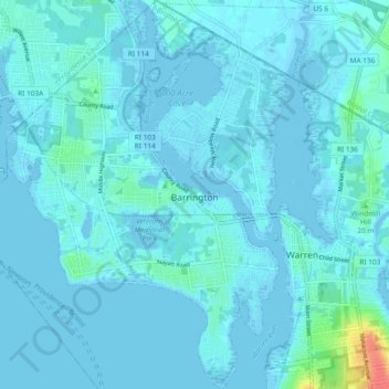
Name: Topografische Karte Barrington, Höhe, Relief.
Durchschnittliche Höhe: 4 m
Minimale Höhe: -7 m
Maximale Höhe: 47 m
Barrington lies on a low, mostly flat plain bordering the sea. This plain, composed mostly of layers of clay, gravel, sand, and silt soils, was formed by a melting glacier towards the end of the last ice age. Bedrock underlying the soil is largely composed of shales, sandstone, and conglomerate rock, with some outcrops of quartz. A few extremes in elevation, such as Nayatt Point, Primrose and Prince's Hill, rise to heights of fifty feet.