
Topografische Karte Hong Kong Park
Interaktive Karte
Klicken Sie auf die Karte, um die Höhe anzuzeigen.
Über diese Karte
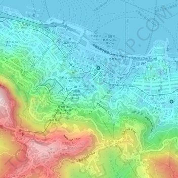
Name: Topografische Karte Hong Kong Park, Höhe, Relief.
Durchschnittliche Höhe: 143 m
Minimale Höhe: -3 m
Maximale Höhe: 492 m
Andere topografische Karten
Klicken Sie auf eine Karte, um ihre Topografie, ihre Höhe und ihr Relief anzuzeigen.
Pok Fu Lam Country Park
Pok Fu Lam Country Park, Lugard Road, Mid-levels, Hong Kong, Central and Western District, Hong Kong, CENTRAL, PRC
Durchschnittliche Höhe: 185 m
Lung Fu Shan
Lung Fu Shan, Hong Kong, Central and Western District, Hong Kong, 1F, PRC
Durchschnittliche Höhe: 136 m
Pak Tsz Lane Park
Pak Tsz Lane Park, Admiralty, Sheung Wan, Hong Kong, Central and Western District, Hong Kong, PRC
Durchschnittliche Höhe: 113 m
Blake Garden
Blake Garden, Admiralty, Mid-levels, Hong Kong, Central and Western District, Hong Kong, PRC
Durchschnittliche Höhe: 116 m
Tamar Park
Tamar Park, Admiralty, Central District, Hong Kong, Central and Western District, Hong Kong, PRC
Durchschnittliche Höhe: 80 m
Cheung Kong Park
Cheung Kong Park, Cheung Kong Center, Central District, Hong Kong, Central and Western District, Hong Kong, PRC
Durchschnittliche Höhe: 132 m