
Topografische Karte Κάτω Στενή
Interaktive Karte
Klicken Sie auf die Karte, um die Höhe anzuzeigen.
Über diese Karte
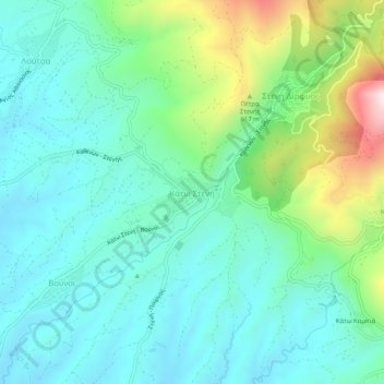
Name: Topografische Karte Κάτω Στενή, Höhe, Relief.
Durchschnittliche Höhe: 369 m
Minimale Höhe: 201 m
Maximale Höhe: 893 m
Andere topografische Karten
Klicken Sie auf eine Karte, um ihre Topografie, ihre Höhe und ihr Relief anzuzeigen.
Agia Irini
Greece > Thessaly and Central Greece > Euboea Regional Unit
Agia Irini, Dirfyon - Messapion Municipality, Euboea Regional Unit, Central Greece, Thessaly and Central Greece, 340 14, Greece
Durchschnittliche Höhe: 399 m
Stropones
Greece > Thessaly and Central Greece > Euboea Regional Unit
Stropones, Dirfyon - Messapion Municipality, Euboea Regional Unit, Central Greece, Thessaly and Central Greece, 340 14, Greece
Durchschnittliche Höhe: 588 m
Agios
Greece > Thessaly and Central Greece > Euboea Regional Unit
Agios, Dirfyon - Messapion Municipality, Euboea Regional Unit, Central Greece, Thessaly and Central Greece, 344 00, Greece
Durchschnittliche Höhe: 502 m
Marmari
Greece > Thessaly and Central Greece > Euboea Regional Unit
Marmari, Karystos Municipality, Euboea Regional Unit, Central Greece, Thessaly and Central Greece, 340 13, Greece
Durchschnittliche Höhe: 99 m
Karystos
Greece > Thessaly and Central Greece > Euboea Regional Unit
Karystos, Karystos Municipality, Euboea Regional Unit, Central Greece, Thessaly and Central Greece, 340 01, Greece
Durchschnittliche Höhe: 167 m
Αιδηψός
Greece > Thessaly and Central Greece > Euboea Regional Unit
Αιδηψός, Istiaia-Aidipsos Municipality, Euboea Regional Unit, Central Greece, Thessaly and Central Greece, 343 00, Greece
Durchschnittliche Höhe: 113 m
Agios Ioannis
Greece > Thessaly and Central Greece > Euboea Regional Unit
Agios Ioannis, Kymi - Aliveri Anna Municipality, Euboea Regional Unit, Central Greece, Thessaly and Central Greece, 345 00, Greece
Durchschnittliche Höhe: 129 m
Xirovrysi
Greece > Thessaly and Central Greece > Euboea Regional Unit > Municipal Unit of Anthidon
Xirovrysi, Municipal Unit of Anthidon, Municipality of Chalkida, Euboea Regional Unit, Central Greece, Thessaly and Central Greece, 341 31, Greece
Durchschnittliche Höhe: 15 m
Skyros
Greece > Thessaly and Central Greece > Euboea Regional Unit
Skyros, Euboea Regional Unit, Central Greece, Thessaly and Central Greece, 340 07, Greece
Durchschnittliche Höhe: 61 m
Chalkida
Greece > Thessaly and Central Greece > Euboea Regional Unit
Chalkida, Municipality of Chalkida, Euboea Regional Unit, Central Greece, Thessaly and Central Greece, 341 09, Greece
Durchschnittliche Höhe: 129 m